Pa Sak Jolasid Dam
| Pa Sak Cholasit Dam | |
|---|---|
 View of Pa Sak Cholasit Dam with the Dong Phaya Yen Range in the background | |
| Country | Thailand |
| Location | Phatthana Nikhom, Lopburi |
| Coordinates | 14°51′41″N 101°03′58″E / 14.86139°N 101.06611°E |
| Status | Operational |
| Construction began | 1991 |
| Opening date | 1999 |
| Dam and spillways | |
| Type of dam | Embankment, earth-fill |
| Impounds | Pa Sak River |
| Height | 36.5 m (120 ft) |
| Length | 4,860 m (15,940 ft) |
| Reservoir | |
| Total capacity | 960,000,000 m3 (778,285 acre⋅ft) |
| Power Station | |
| Installed capacity | 6.7 MW |
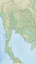
The Pa Sak Jolasid Dam or Pa Sak Cholasit Dam (Template:Lang-th, RTGS: Khuean Pa Sak Chonlasit pronounced [kʰɯ̀a̯n pàː sàk t͡ɕʰōn.lā.sìt]) impounds the Pa Sak River at Ban Kaeng Suea Ten, Tambon Nong Bua, Phatthana Nikhom District, Lopburi Province, Thailand. It is the biggest reservoir in central Thailand.[1]
The 4,860-meter (15,940 ft) wide and 36.5-meter (120 ft) high dam is earth-filled with an impervious core. The storage capacity is 785 million m3 of water at normal water level, with a maximum capacity of 960 million m3. The dam also supplies about 6.7 MW of hydro-electric power.
History
The Pa Sak Cholasit Dam Project is one of the major irrigation projects of Thailand, providing water to the plantations in the Pa Sak valley and lower Chao Phraya valley. The dam also decreases problems of water management in Bangkok by permitting more flood control, as the Pa Sak river was one of the main sources of flooding in the Bangkok metropolitan area.
King Bhumibol Adulyadej initiated a project to develop the Pa Sak River valley and lower Chao Phraya valley on 19 February 1989 as part of the Maenam Pa Sak Royal Development Project. On 4 July 1991 Prime Minister Anand Panyarachun set up a study group for the dam project. Princess Maha Chakri Sirindhorn presided over a royal ceremony on 15 June 1998, starting the storing of water in the reservoir.
On 20 October 1991 King Bhumibol Adulyadej gave the dam its official name, Pa Sak Cholasit. The king also presided over the inauguration of the dam on 25 November 1999. The park is now also a tourist attraction .
Travel by train

From November to January of the following year annually, a total of three months, the State Railway of Thailand (SRT) will open a special train for traveling from Hua Lamphong (Bangkok railway station) to here. It will be available only on Saturdays and Sundays, the excursion trains will leave Hua Lampong railway station at 7.10 am and reach the dam in Saraburi at 11.40 am. It will depart the dam at 3.30 pm and reach Hua Lampong at 6.20 pm.
The main highlight of this trip is to take a photo on the dam ridge where the train stops, allowing passengers to stroll and take pictures.[2] [3]
References
- ^ "Pa Sak Jolasid Dam". TAT. Archived from the original on 5 November 2015. Retrieved 8 August 2015.
- ^ "Train trips to Pasak Jolasid Dam begin next month". The Nation. 2018-10-30. Retrieved 2019-12-22.
- ^ "นั่งรถไฟเที่ยวเขื่อนป่าสักชลสิทธิ์" [Takes a train travel to Pa Sak Jolasid Dam]. SRT (in Thai).


