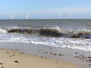
Scroby Sands Wind Farm
| Scroby Sands Wind Farm | |
|---|---|
 Scroby Sands Wind Turbines | |
 | |
| Country | United Kingdom, England |
| Location | off the coast of Great Yarmouth, Norfolk |
| Coordinates | 52°38′56″N 1°47′25″E / 52.64889°N 1.79028°E |
| Status | Operational |
| Construction began | October 2003[1] |
| Commission date | March 2004[2] |
| Construction cost | €87 million |
| Owner | E.ON UK |
| Wind farm | |
| Type | Offshore |
| Max. water depth | 5–10 m (16–33 ft) |
| Distance from shore | 2.5 km (1.6 mi) |
| Hub height | 68 m (223 ft) |
| Rotor diameter | 80 m (260 ft) |
| Rated wind speed | 16 m/s (58 km/h) |
| Power generation | |
| Units operational | 30 x 2 MW |
| Make and model | Vestas V80-2MW |
| Nameplate capacity | 60 MW |
| Capacity factor | 32.42% (2012) |
| External links | |
| Commons | Related media on Commons |
The Scroby Sands Wind Farm is a wind farm located on the Scroby Sands sandbank in the North Sea, 2.5 kilometres (1.6 mi) off the coast of Great Yarmouth in eastern England, United Kingdom. It was commissioned in March 2004 by Powergen Renewables Offshore, a division of E.ON UK. It has a nameplate capacity of 60 megawatts and is able to produce power to supply 41,000 households. Between 2005 and 2010, its capacity factor was between 26 and 32%.[3] Its levelised cost has been estimated at £105/MWh.[4]
The farm consists of 30 wind turbines, located in water from 13 to 20 metres (43 to 66 ft) deep. Each turbine has three 40-metre (130 ft) blades that rotate around a centre-point some 60 metres (200 ft) above the mean sea level. The hollow 4.5-metre (14.8 ft) diameter steel masts that carry the turbines are piled as much as 30 metres (98 ft) into the sea bed, to provide stability on a substrate of shifting sands. These shifting sands have piled up and decreased water depth, blocking access from service vessels. An amphibious vehicle is being built to drive on the sand to gain access to the turbines.[5]
The wind turbines were designed and manufactured by a Danish firm, Vestas. Each turbine has a capacity of 2 megawatts.[6] Turbines were installed by the Danish offshore wind farms services provider A2SEA.[7]
Tourism
The wind farm has an information centre serving around 35,000 visitors per year, and has become a local attraction.[8][9]
Gallery
-
Wind farm seen from Great Yarmouth
-
Information board at Great Yarmouth
-
A Jackup rig servicing one of the wind turbines
See also
- Wind power in the United Kingdom
- Sheringham Shoal Offshore Wind Farm
- List of offshore wind farms
- List of offshore wind farms in the United Kingdom
- List of offshore wind farms in the North Sea
References
- ^ "Renewable Energy Planning Database (REPD): June 2020". GOV.UK. UK Government. Retrieved 24 September 2020.
- ^ "Offshore wind farm Scroby Sands". RWE. RWE. Retrieved 24 September 2020.
- ^ Dunford et al. UK Renewable Energy Data, Issue 10 p53 Renewable Energy Foundation, 29 July 2010. Accessed: 30 September 2011.
- ^ Aldersey-Williams, John; Broadbent, Ian; Strachan, Peter (2019). "Better estimates of LCOE from audited accounts – A new methodology with examples from United Kingdom offshore wind and CCGT". Energy Policy. 128: 25–35. doi:10.1016/j.enpol.2018.12.044. hdl:10059/3298.
- ^ "World-first amphibious crew transfer vessel to make its debut at RWE windfarm". Riviera. 7 March 2022.
- ^ "Datasheet for Scroby Sands". LORC Knowledge. 2011-03-14. Retrieved 2011-06-20.
- ^ "A2SEA presentation" (PDF). A2SEA. Export Promotion Denmark. 2005-04-12. Retrieved 2010-07-14.
- ^ "Scroby Sands Offshore Wind Farm, United Kingdom". powertechnology.com. Net Resources International. Retrieved 2009-08-22.
- ^ "Tourism and wind farms". E.ON UK. Retrieved 2009-08-22.
External links
- Capital Grant Scheme for Offshore Wind Annual Report – January 2005 – December 2005 from the Department of Trade and Industry. The main finding being that - apparently owing to a series of bearing failures, and four generator failures - production in the year was less to 30% of the farm's nameplate capacity (albeit this represents production of 90% of the farm's forecast annual output.
- Performance report into wind farm from the BBC, based on the above report.
- E.ON UK - Scroby Sands E.ON's page about Scroby Sands.


