Tyendinaga, Ontario
Tyendinaga | |
|---|---|
| Township of Tyendinaga | |
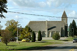
 Marysville | |
| Coordinates: 44°18′N 77°12′W / 44.300°N 77.200°W | |
| Country | |
| Province | |
| County | Hastings |
| Incorporated | 1820 |
| Government | |
| • Type | Township |
| • Reeve | Claire Kennelly |
| • Federal riding | Hastings—Lennox and Addington |
| • Prov. riding | Hastings—Lennox and Addington |
| Area | |
| • Land | 312.92 km2 (120.82 sq mi) |
| Population (2016)[1] | |
• Total | 4,297 |
| • Density | 13.7/km2 (35/sq mi) |
| Time zone | UTC-5 (EST) |
| • Summer (DST) | UTC-4 (EDT) |
| Postal Code | K0K |
| Area code(s) | 613, 343 |
| Website | www.tyendinagatownship .com |
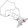
Tyendinaga is a township in the Canadian province of Ontario, located in Hastings County. The community takes its name from a variant spelling of Mohawk leader Joseph Brant's traditional Mohawk name, Thayendanegea.
Communities
The township comprises the communities of Albert, Blessington, Chisholms Mills, Ebenezer, Halston, Kingsford, Lonsdale, Lonsdale Station, Melrose, Marysville, Milltown, Myrehall, Naphan, Read and Shannonville.
A radio transmitter for the Canadian Broadcasting Corporation is located in Read.[2] Saint Charles Borromeo Cemetery is also located in Read.
Demographics
In the 2021 Census of Population conducted by Statistics Canada, Tyendinaga had a population of 4,538 living in 1,650 of its 1,730 total private dwellings, a change of 7.4% from its 2016 population of 4,226. With a land area of 312.42 km2 (120.63 sq mi), it had a population density of 14.5/km2 (37.6/sq mi) in 2021.[3]
| 2016 | 2011 | |
|---|---|---|
| Population | 4,297 (+3.5% from 2011) | 4,150 (+2.0% from 2006) |
| Land area | 312.92 km2 (120.82 sq mi) | 313.00 km2 (120.85 sq mi) |
| Population density | 13.7/km2 (35/sq mi) | 13.3/km2 (34/sq mi) |
| Median age | 42.5 (M: 42.5, F: 42.6) | |
| Private dwellings | 1,631 (total) | 1,547 (total) |
| Median household income | $81,408 |
| Year | Pop. | ±% |
|---|---|---|
| 1991 | 3,118 | — |
| 1996 | 3,549 | +13.8% |
| 2001 | 3,769 | +6.2% |
| 2006 | 4,070 | +8.0% |
| 2011 | 4,150 | +2.0% |
| 2016 | 4,295 | +3.5% |
| [8][9][1] | ||
Mother tongue (2016 census):[1]
- English as first language: 97.4%
- French as first language: 0.7%
- Other as first language: 1.9%
Industry
Shipman’s Flour and Sawmill was constructed in 1851 and bought by William Fraser Chisholm in 1857, and known as Chisholm's Mills since.[10]
See also
References
- ^ a b c d "Census Profile, 2016 Census: Tyendinaga, Township". Statistics Canada. 8 February 2017. Retrieved June 15, 2019.
- ^ "CBC Channels and Frequencies". CBC Radio.
- ^ "Population and dwelling counts: Canada, provinces and territories, census divisions and census subdivisions (municipalities), Ontario". Statistics Canada. February 9, 2022. Retrieved April 2, 2022.
- ^ "2016 Community Profiles". 2016 Canadian census. Statistics Canada. August 12, 2021. Retrieved 2019-06-15.
- ^ "2011 Community Profiles". 2011 Canadian census. Statistics Canada. March 21, 2019. Retrieved 2012-03-02.
- ^ "2006 Community Profiles". 2006 Canadian census. Statistics Canada. August 20, 2019.
- ^ "2001 Community Profiles". 2001 Canadian census. Statistics Canada. July 18, 2021.
- ^ Statistics Canada: 1996, 2001, 2006 census
- ^ "Tyendinaga census profile". 2011 Census of Population. Statistics Canada. Retrieved 2012-03-02.
- ^ "CULTIVATING CREATIVITY: More than a century of art at Chisholm's Mill". intelligencer.ca. 13 Dec 2019. Retrieved 2022-07-04.


