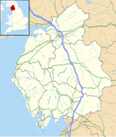
Thornthwaite
This article needs additional citations for verification. (September 2019) |
| Thornthwaite | |
|---|---|
 St. Mary's Church, Thornthwaite | |
| OS grid reference | NY222254 |
| Civil parish | |
| District | |
| Shire county | |
| Region | |
| Country | England |
| Sovereign state | United Kingdom |
| Post town | KESWICK |
| Postcode district | CA12 |
| Dialling code | 017687 |
| Police | Cumbria |
| Fire | Cumbria |
| Ambulance | North West |
| UK Parliament | |
Thornthwaite is a village in Cumbria, England. Historically in Cumberland, it is just off the A66 road, south of Bassenthwaite Lake and within the Lake District National Park. It is 3.5 miles (5.6 km) by road from Keswick.[1] In 1861 the township had a population of 153.[2] The place-name contains thwaite ("clearing").[3]
For administrative purposes, Thornthwaite lies within the civil parish of Above Derwent, the district of Allerdale, and the county of Cumbria. It is within the Copeland constituency of the United Kingdom Parliament. Prior to Brexit in 2020 it was part of the North West England constituency of the European Parliament.[1]
St Mary's Church is located a short distance east of the village. It was built in 1831, replacing an earlier church of c.1760 on the same site.[4] The Church is a Grade II listed building.[5]
References
- ^ a b "Election Maps". Ordnance Survey. Retrieved 20 January 2010.
- ^ "History of Thornthwaite, in Allerdale and Cumberland". A Vision of Britain through Time. Retrieved 13 January 2022.
- ^ Smith, Albert Hugh (1962). The Place-names of the West Riding of Yorkshire. University Press.
þveit […] Sarthwaite, Slaithwaite, Smorthwaite
- ^ "Church of St Mary, Thornthwaite | Co-Curate". co-curate.ncl.ac.uk. Retrieved 30 March 2020.
- ^ Historic England. "CHURCH OF ST MARY, Above Derwent (1144575)". National Heritage List for England. Retrieved 30 March 2020.
External links
- Cumbria County History Trust: Above Derwent (nb: provisional research only – see Talk page)


