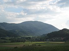
Boč


Boč, also called the Triglav of Slovene Styria ,[1] is a 978-metre-high (3,209 ft)[2] mountain in eastern Slovenia.[1] It belongs to the municipalities of Poljčane (the peak) and Rogaška Slatina (southern slope). Boč, which is among the southernmost extensions of the Karawanks mountain range,[1] is the central mountain of the Boč–Donatus Mountain Landscape Park. It has two peaks, which are five minutes apart.[1] At one peak, there are transmitters (restricted military area). In the other, a 20-metre (66 ft) lookout tower has stood since 1962.[1] The mountain, covered with forest and protected as a natural park, has a number of trails that vary in difficulty level and is also home to the protected Greater Pasque Flower (Pulsatilla grandis).[3] The plant grows in the vicinity of St. Nicholas Church (Parish of Kostrivnica) and the Hut Under Mt. Boč on the southern slope of Boč. A sculpture of the Greater Pasque Flower, work of the sculptor Franc Tobias from Razvanje, has been put on display on a small rise near its growing place.
References
- ^ a b c d e "27: Trail to Boč: The Triglav of Slovene Styria" (PDF). Slovenian Styria: Maribor, Pohorje, Slovenske gorice and Dravsko polje. TIC Maribor. February 2012. p. 50.
- ^ Cilenšek, Milan (10 June 1998). "Planinska znamka - Boč, 978 m" [Mountaineering Stamp - Boč, 978 m] (in Slovenian). Pošta Slovenije [Post of Slovenia].
- ^ Walking Paths of Rogaška Slatina - Hiking Trekking - Slovenia - Official Travel Guide
External links
 Media related to Boč (mountain) at Wikimedia Commons


