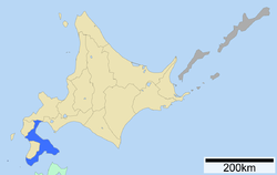
Oshima Subprefecture
Appearance
Oshima Subprefecture
渡島総合振興局 | |
|---|---|
| Oshima-sōgō-shinkō-kyoku | |
 | |
| Prefecture | Hokkaido |
| Capital | Hakodate |
| Area | |
• Total | 3,936.32 km2 (1,519.82 sq mi) |
| Population (March 2009) | |
• Total | 449,371 |
| • Density | 110/km2 (300/sq mi) |
| Website | oshima.pref.hokkaido.lg.jp |


Oshima (渡島総合振興局, Oshima-sōgō-shinkō-kyoku) is a subprefecture of Hokkaido Prefecture, Japan. As of 2004, it had a population of 456,621 and an area of 3,715.38 km2.
Hakodate Airport is located in the City of Hakodate.
Geography
The subprefecture is located on the Oshima Peninsula.
Municipalities
| Name | Area (km2) | Population | District | Type | Map | |
|---|---|---|---|---|---|---|
| Rōmaji | Kanji | |||||
| 福島町 | 187.23 | 4,390 | Matsumae District | Town | 
| |
| 函館市 | 677.89 | 264,845 | no district | City | 
| |
| 北斗市 | 397.29 | 46,083 | no district | City | 
| |
| 木古内町 | 221.88 | 4,448 | Kamiiso District | Town | 
| |
| 松前町 | 293.11 | 7,843 | Matsumae District | Town | 
| |
| 森町 | 378.27 | 16,299 | Kayabe District | Town | 
| |
| 七飯町 | 216.61 | 28,514 | Kameda District | Town | 
| |
| 長万部町 | 310.75 | 5,694 | Yamakoshi District | Town | 
| |
| 鹿部町 | 110.61 | 3,920 | Kayabe District | Town | 
| |
| 知内町 | 196.67 | 4,620 | Kamiiso District | Town | 
| |
| 八雲町 | 955.98 | 17,299 | Futami District | Town | 
| |
Mergers
History
- 1897: Hakodate Subprefecture, Kameda Subprefecture, and Matsumae Subprefecture was established.
- 1899: Hakodate Subprefecture was abolished. Kameda Subprefecture was transferred to Hakodate and renamed Hakodate Subprefecture.
- 1903: Matsumae Subprefecture was merged into Hakodate Subprefecture.
- 1922: Hakodate Subprefecture changed its name to Oshima Subprefecture.
External links
Wikivoyage has a travel guide for Oshima Subprefecture.
- (in Japanese) Official website
41°49′11″N 140°45′12″E / 41.819755°N 140.753278°E 41°25′45″N 140°06′41″E / 41.429146°N 140.111361°E(Matsumae General Branch Office)
