Tutuila
| Tutuila | |
|---|---|
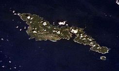
 Tutuila and Aunu‘u from the Space Shuttle. | |
| Elevation: | 653 m (2,142 feet) |
| Coordinates: | 14°17′42″S 170°42′00″W / 14.295°S 170.70°W |
| Location: | United States |
| Range: | Samoa Islands |
| Type: | Shield volcano |
| Last eruption: | Unknown |
| First ascent: | |
| Easiest route: | |
Tutuila is the main or largest island of American Samoa, and the third largest island in the Samoan Island chain (see Samoa). The island is distinctive in the Central Pacific for its large, natural harbor—Pago Pago Harbor—on which the capital of American Samoa, Pago Pago, is located.

The area of the island is 141.81 km² (54.75 sq mi), and it has a 2000 census population of 55,876. (These figures include Aunu'u Island, off the southeast coast of Tutuila, which has a land area of 1.517 km² and a population of 476.) The highest point on the island is Matafao peak (653 m or 2142 ft). In the early 19th century, Tutuila was called Maouna. Politically, the island is divided into two of American Samoa's primary divisions, the Eastern District and the Western District.
References
- Siebert L, Simkin T (2002–present). Volcanoes of the World: an Illustrated Catalog of Holocene Volcanoes and their Eruptions. Smithsonian Institution, Global Volcanism Program Digital Information Series, GVP-3 (http://www.volcano.si.edu).
- Tutuila: Eastern District and Western District, United States Census Bureau

