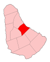
Saint Joseph, Barbados
Appearance
| Statistics | |
|---|---|
| Parish: | Saint Joseph |
| Area: | 26km² (10 sq. mi.) |
| Largest City: | Bathsheba |
| Population (1990 est.): | 7,204 inhab. |
| Population Density: | 277,08 inhab/km² |
| Parliamentary representation | |
| - House seats | 1 |
| Map | |
 | |
| Parishes of Barbados | |
The parish of Saint Joseph is a parish of Barbados on the eastern side of the island. The parish is home to two of the more notable botanic gardens in the country - Flower Forest and Andromeda Gardens. Parts of St. Joseph are also referred to as the Scotland District, a reference to the appearance of the landscape.
The main town in the parish is Bathsheba
Wikimedia Commons has media related to Saint Joseph Parish, Barbados.
