Maryland Route 468
 | ||||
| Route information | ||||
| Maintained by MDSHA | ||||
| Length | 11.19 mi[1] (18.01 km) | |||
| Major junctions | ||||
| South end | Snug Harbor Road in Shady Side | |||
| North end | ||||
| Location | ||||
| Country | United States | |||
| State | Maryland | |||
| Highway system | ||||
| ||||
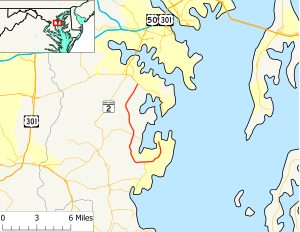
Maryland Route 468 (MD 468) is a state highway in the U.S. state of Maryland. The route runs 11.19 mi (18.01 km) from Snug Harbor Road in Shady Side north to Maryland Route 214 in Edgewater.
Route description
Maryland Route 468 begins as Shady Side Road at an intersection with West Shady Side Road, which heads north to access residences around Deadwood Cove and the Capt. Salem Avery House, and Snug Harbor Road, which heads east toward Snug Harbor Park and the Idlewilde peninsula. The east-west-marked route heads south as a two-lane road with a speed limit of 30 mph (48 km/h) through forests and the small residential communities scattered throughout Shady Side. After passing Cedarhurst Road, MD 468 intersects Columbia Beach Road, which in conjunction with Bay Breeze Road, Scott Town Road, and Nick Road forms an old alignment of MD 468. The speed limit increases to 45 mph (72 km/h) after the road passes Columbia Beach Road and starts to curve to the west. Shortly after passing Deep Cove Road, MD 468 passes Churchton Recreation Area and enters a small commercial area in Churchton, where the road intersects Maryland Route 256 (Deale Churchton Road) and Chalk Point Road. The road's name changes to Muddy Creek Road at MD 256.
After leaving the commercial area in Churchton, MD 468 enters farmland and meets Swamp Circle Road, then curves to the northwest and passes the intersection of Sudley Road and Plantation Boulevard. Sudley Road, as well as Old Sudley Road a short way to the north, provides access to the historic home Sudley. MD 468 then turns north, crosses three small creeks that flow into the West River, and intersects Maryland Route 255 (Galesville Road/Owensville Road) immediately to the west of the unincorporated village of Galesville. The route becomes marked north-south immediately before the MD 255 intersection.
North of MD 255, MD 468 passes three historic homes: Tulip Hill, which is accessed directly from the route; and Cedar Park and Parkhurst, which are both found by turning onto Cumberstone Road. The speed limit increases to 50 mph (80 km/h) after Cumberstone Road. After passing Old Muddy Creek Road, an old alignment, the road crosses over several branches of Muddy Creek within the Birds Mill Swamp. Within the swamp, the old alignment splits off to the east and MD 468 encounters Mill Swamp Road. After leaving the swamp, the road passes Contee Wharf Road and South River Clubhouse Road. The former road leads east to the Smithsonian Environmental Research Center, while the latter passes the historic meeting place of the South River Club. After passing another old alignment of MD 468 in Clydesdale Road, the road meets its northern terminus at Maryland Route 214 (Central Avenue) in Edgewater.
History

The road that forms the current course of Maryland Route 468 was paved between Galesville and Churchton by 1927.[2] By 1933, the whole route was paved with exception of a 1.5 mi (2.4 km) gap north of Galesville.[3] This gap was filled by 1935.[4] However, as the 1939 Maryland State Highway map shows, the segment of MD 468 south of Galesville was part of an extended Maryland Route 255.[5] MD 468 and MD 255 assumed their present alignments in 1949.[6]
Junction list
The entire route is in Anne Arundel County.
| Location | Mile[1] | Destinations | Notes |
|---|---|---|---|
| Shady Side | 0.00 | Snug Harbor Road
West Shady Side Road |
Southern terminus |
| 0.89 | Cedarhurst Road | ||
| 1.15 | Columbia Beach Road | ||
| 2.04 | Deep Cove Road | ||
| Churchton | 2.83 | ||
| 2.95 | Chalk Point Road | ||
| 3.55 | Swamp Circle Road | ||
| Sudley | 3.81 | Sudley Road / Plantation Boulevard | |
| 4.60 | Old Sudley Road | ||
| Galesville | 6.23 | ||
| 6.68 | Cumberstone Road | ||
| Edgewater | 8.79 | Mill Swamp Road | |
| 10.24 | Contees Wharf Road / South River Clubhouse Road | ||
| 11.19 | Northern terminus |
References
- ^ a b Maryland State Highway Administration (2008). "Highway Location Reference: Anne Arundel County" (PDF). Retrieved 2010-01-15.
- ^ Maryland State Highway Administration (1927). "Map of Maryland" (JPG). Retrieved 2010-01-15.
- ^ Maryland State Highway Administration (1933). "Map of Maryland" (PDF). Retrieved 2010-01-15.
- ^ Maryland State Highway Administration (1935). "Map of Maryland" (PDF). Retrieved 2010-01-15.
- ^ Maryland State Highway Administration (1939). "Map of Maryland" (PDF). Retrieved 2010-01-15.
- ^ Maryland State Highway Administration (1949). "Map of Maryland" (PDF). Retrieved 2010-01-15.

