Comăna
Comăna | |
|---|---|
Commune | |
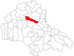
 Location of Comăna, Braşov | |
| Country | |
| County | Braşov County |
| Status | Commune |
| Government | |
| • Mayor | Viorel Grusea (PNL) |
| Area | |
• Total | 100 km2 (40 sq mi) |
| Population (2004) | |
• Total | 2,635 |
| Time zone | UTC+2 (EET) |
| • Summer (DST) | UTC+3 (EEST) |
Comǎna (Template:Lang-de) is a commune in Braşov County, Romania. The commune has four villages: Comăna de Jos, Comăna de Sus, Crihalma and Ticușu Nou. The city hall lies in Comăna de Jos. The Comăna commune is situated in the middle of Romania, on the Olt River. The distance from the city of Făgăraş is 27 km, and the city of Rupea is situated at 20 km.
History
In the current Comăna de Jos were discovered several human settlements, that attest the existence of early people on these places: the Bronze Age settlement from the 2nd - 1st century B.C. La Tène (Cowboy Hill) is represented by a Hallstatt settlement of 8th-9th century and one of 11th-13th century from the early medieval era. In the Low Comana (Comăna de Jos)were investigated dwellings dug into the soil at different depths, being unveiled 14 huts and 18 little huts [2], with diverse planimetry with installation of fire ovens consisting of stone and clay [3]. Was also found and existing facilities upgraded fire outdoors. Archaeological research 1974-1976 concluded that construction traces, ruins and ceramics (by wheel and by hand) belong to various periods of time. Ceramic found here is similar to the one found in the areas inhabited by Dacians
Comăna de Jos was an important administrative center of the eastern part of Făgăraș land, when Ștefan Mailat - who was born here in 1502 - ruled over Transylvania. Villages falling within the jurisdiction of this center were: Upper Comăna (Comăna de Sus), the Lower Venice, the Upper Venice, Crihalma (the King's Hill), the New Ticuşu, Cuciulata and Lupșa.
In the year 1733, when the Greek Catholic bishop Micu-Klein Inocenţiu decided to organize a census [5] in Transylvania, in the village of Lower Comana were reviewed of 34 families. In other words, in the Lower Comana of the year 1733, lived around 170 inhabitants. In the same census is to be noted in the Lower Comana two censuses were Greek Catholic priests, both having Iuon surname. In the Lower Comana there was a Greek Catholic church and a manse. [6] The name of the village was played in Hungarian: Alsó-Komana, whereas the results were intended to a committee consisting of non-Romanians, mostly Hungarians. [7] In the church, the Lower Comana year 1733 kept Protopopiatul in the neighboring town, the Lower Venice [8] [6]. Also in census of 1733 states that the Greek Catholic parish in the Lower Comana collected 11 carts of hay. [6]
In the interwar period and until the administrative reform of 6 September 1950 Comăna was part of the Făgăraş county who had the headquarter in the town of Făgăraş.
Since 1950, when the administrative-territorial division, the counties of Romania were replaced after the Soviet model, into districts and regions, and to administrative reform in 1968, the Lower Comana was part of Făgăraş district, Brasov region. Between 1950 - 1960, the Braşov region was named Stalin, with the capital in Stalin City, now Braşov.
Population
In the year of 2002 the population of Comăna commune was of 2,635 inhabitants.
The population between 1850 and 2002 according to the official Hungarians and Romanian censuses.
| Census of Comăna | Ethnic structure | |||||||
|---|---|---|---|---|---|---|---|---|
| Year | Population | Romanians | Hungarians | Germans | Rroma | Ukrainians | Other | |
| 1850 | 3.437 | 3.311 | 9 | - | 117 | |||
| 1857 | 3.578 | |||||||
| 1880 | 3.419 | 3.140 | 124 | 10 | 147 | |||
| 1890 | 3.383 | 3.164 | 158 | 9 | 52 | |||
| 1900 | 3.435 | 3.223 | 145 | 34 | 33 | 1 | ||
| 1910 | 3.580 | 3315 | 177 | 25 | 63 | 5 | 1 | |
| 1920 | 3.620 | 3.569 | 37 | 14 | ||||
| 1930 | 3.519 | 3.442 | 38 | 7 | 32 | |||
| 1941 | 3.312 | 3.69 | 18 | - | 225 | |||
| 1956 | 3.254 | 2.956 | 20 | 2 | 276 | |||
| 1966 | 3.135 | 2.867 | 23 | - | 245 | |||
| 1977 | 2.822 | 2.351 | 9 | 3 | 459 | |||
| 1992 | 2.619 | 1.575 | 11 | 1 | 1.032 | |||
| 2002 | 2.635 | 2.005 | 11 | 0 | 616 | 1 | 2 | |
Natives
Ștefan Mailat (1502–1550) - captain of Făgăraș Castel and Priceps of Transylvania.
Gallery
-
Old map of Comăna de Jos and the area
-
View over Comăna commune
-
Church in Comăna de Jos


