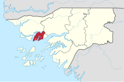
Biombo region
11°50′N 15°45′W / 11.833°N 15.750°W
Biombo | |
|---|---|
 Biombo Region in Africa | |
| Country | Guinea-Bissau |
| Seat | Quinhámel |
| Sectors | Prabis, Quinhámel, Safim |
| Area | |
• Total | 838.8 km2 (323.9 sq mi) |
| Population (2009 census) | |
• Total | 97,120 |
| • Density | 120/km2 (300/sq mi) |
| ISO 3166 code | GW-BM |
Biombo is a region in western Guinea-Bissau, with an area of 840 km2. Its capital is Quinhámel. Its population in 2004 was 63,835, compared with 60,400 at the 1991 Census.
Sectors in the region

Biombo is divided into 3 sectors:
Demographics
| Year | Pop. | ±% |
|---|---|---|
| 2005 | 84,489 | — |
| 2006 | 86,558 | +2.4% |
| 2007 | 88,673 | +2.4% |
| 2008 | 90,832 | +2.4% |
| 2009 | 93,039 | +2.4% |
| 2010 | 95,294 | +2.4% |
| 2011 | 97,596 | +2.4% |
| 2012 | 99,947 | +2.4% |
| Sources:[1] | ||
As of 2009, the total population of the region was 93,039, with the urban population being 11,030 and rural being 82,009. The sex ratio of the region is 89 females for every hundred males. The total resident population in the region is 93,039. The total agricultural population in the region is 32,012. The average number of household in the region is 7.0 and the density of the population is 110.9 sq. km. The intercensal rate of average annual growth (adjusted data) is 2.69 per cent. The non-agricultural population in the country is 61,027. The total number of households per capita in the region is 13,328. The fraction of Christians in the region is 30.2 per cent, Muslims is 6.30 per cent, animists is 40.10 per cent, not detailed was 20.80 per cent and people following no religion was 2.5 per cent.[1]
Economy
As of 2009, there net activity rate was 50.47 per cent, proportion of employed labour force was 35.03 per cent, proportion of labour force was 77.74 and the proportion of potentially active population was 35.03 per cent.[2] The major economic activity in the parts around the rivers and the coastal areas is fishing, while it is agriculture in the inland areas. As of 2011, the total population which is active constitutes 60 per cent nationwide indicating there are lot of employed people. But the poverty rate is very high in the country with an estimated two-thirds below the poverty line. Out of the working population, an estimated 58.4 per cent are employed in freelance activities, while wage earners formed 42 per cent. The unemployment in the region as of 2001 was 10.2 per cent, compared to the capital Bissau which has 19.3 per cent. Totally 63.5 per cent were employed in agriculture (including forestry), 8.9 in industry and 6.1 per cent in public administration. As per IMF report in 2011, people who were engaged in agriculture were poorer compared to others, while educated and higher educated people earned more. The absolute poverty rate, people earning less than $2 a day, in the region stood at 63.6 per cent, with a regional contribution of 9.1 per cent to the national poverty totals.[3]
See also
References
- ^ a b "Census of Guinea Bissau, 2012". Central National Institute of Statistics, Guinea Bissau. 2012. Retrieved 12 November 2016.
- ^ "Work profile Guinea Bissau, 2012". Central National Institute of Statistics, Guinea Bissau. 2012. Retrieved 12 November 2016.
- ^ Guinea-Bissau: Second Poverty Reduction Strategy Paper Issues 11-353 of IMF country report. International Monetary Fund. 2011. p. 11.
