Winneba
Winneba
Simpa | |
|---|---|
 North Campus of University of Education, Winneba | |
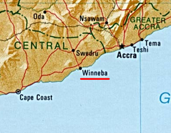
 Winneba is located 56 km (35 mi) west of Accra and 140 km (90 mi) east of Cape Coast | |
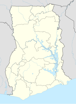
Location of Winneba in Central region, South Ghana | |
| Coordinates: 5°21′00″N 0°37′30″W / 5.35000°N 0.62500°W | |
| Region | Central Region |
| District | Effutu Municipal District |
| Population (2013) | |
• Total | 55,331[1] |
| Time zone | GMT |
| • Summer (DST) | GMT |
Winneba, is a town and the capital of Effutu Municipal District in Central Region of South Ghana. Winneba has a population of 55,331.[1] Winneba, traditionally known as Simpa,[2] is a historic fishing port in south Ghana, lying on the south coast, 140 kilometres (90 mi) east of Cape Coast.[2][3][4] The current member of parliament is Alexander Kwamina Afenyo-Markin.
History
From pre-colonial times through the establishment of the British colony the Gold Coast, (Effutu) Winneba served as a port town.[5] Fort Winneba was built here.
Industry and culture

The main industries of Winneba are fishing and services. It is known for the Aboakyer deer-hunting festival in Winneba and its New Year fancy dress carnival/masquerading festival.[6] The town has a rich musical tradition and currently boasts of several renowned musical groups in the country, including the Winneba Youth Choir, the Osimpam Ompeh group,and the Akoo show Choir. The University of Education, Winneba is one of the educational institutions in Ghana.
Climate
| Climate data for Winneba | |||||||||||||
|---|---|---|---|---|---|---|---|---|---|---|---|---|---|
| Month | Jan | Feb | Mar | Apr | May | Jun | Jul | Aug | Sep | Oct | Nov | Dec | Year |
| Mean daily maximum °C (°F) | 33.0 (91.4) |
32.3 (90.1) |
31.9 (89.4) |
31.1 (88.0) |
34.4 (93.9) |
29.6 (85.3) |
28.3 (82.9) |
29.0 (84.2) |
29.4 (84.9) |
30.6 (87.1) |
32.5 (90.5) |
42.0 (107.6) |
42.0 (107.6) |
| Mean daily minimum °C (°F) | 13.3 (55.9) |
13.6 (56.5) |
11.9 (53.4) |
10.8 (51.4) |
14.5 (58.1) |
13.5 (56.3) |
15.5 (59.9) |
14.2 (57.6) |
12.7 (54.9) |
16.8 (62.2) |
15.7 (60.2) |
12.1 (53.8) |
11.9 (53.4) |
| Average precipitation mm (inches) | 15 (0.6) |
7.6 (0.3) |
10 (0.4) |
38 (1.5) |
220 (8.7) |
66 (2.6) |
38 (1.5) |
7.6 (0.3) |
25 (1.0) |
58 (2.3) |
5.1 (0.2) |
23 (0.9) |
520 (20.3) |
| Source: Meoweather.com[7] | |||||||||||||
Sister cities
List of sister cities of Winneba, designated by Sister Cities International:
| Country | City | County / District / Region / State | Date | Ref. | |||
|---|---|---|---|---|---|---|---|
| USA | Birmingham, AL | Alabama | November 15, 2009 | ||||
| USA | Charlottesville, VA | Virginia | August 2, 2010 | ||||
| USA | Lowell, MA | Massachusetts |
Personalities
- Alex Quaison-Sackey, Ghanaian diplomat.
- Benjamin Moses, Accountant
See also
References
- ^ a b "World Gazetteer online". World-gazetteer.com.
- ^ a b "Central Region". Ghana Embassy in Japan. Retrieved 28 April 2006.
- ^ Kwesi Ewusi Brown, "Social Conflicts in Contemporary Effutu Festivals", 2005, Masters Thesis for Bowling Green State University, advisor Steven Cornelius, p. 1
- ^ Brown, 2005, pp. 2-3
- ^ Brown (2005), p. 1
- ^ Brown, 2005, p. 3
- ^ "Winneba Weather Averages". Meoweather. 2013. Retrieved 21 June 2013.
- ^ "Ghanam Birmingham". birminghamsistercities.com. n.d.
- ^ Tasha Kates (November 15, 2009). "Residents chime in on city clock designs". The Daily Progress.
- ^ Under Resolution


