Estérel, Quebec
Estérel | |
|---|---|
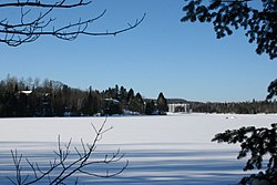
 Lac Dupuis, with Estérel Resort in the background | |
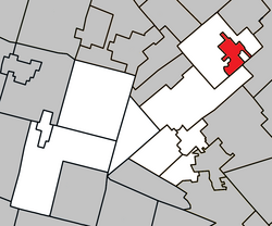
 Location within Les Pays-d'en-Haut RCM | |
| Coordinates: 46°03′N 74°01′W / 46.05°N 74.02°W[1] | |
| Country | |
| Province | |
| Region | Laurentides |
| RCM | Les Pays-d'en-Haut |
| Settled | 1920s |
| Constituted | January 1, 2006 |
| Government | |
| • Mayor | Joseph Dydzak |
| • Federal riding | Laurentides—Labelle |
| • Prov. riding | Bertrand |
| Area | |
• Total | 16.20 km2 (6.25 sq mi) |
| • Land | 12.04 km2 (4.65 sq mi) |
| Population (2017)[3] | |
• Total | 415 registered voters |
| • Density | 16.5/km2 (43/sq mi) |
| • Pop (2006–11) | |
| Time zone | UTC−5 (EST) |
| • Summer (DST) | UTC−4 (EDT) |
| Postal code(s) | |
| Area code(s) | 450 and 579 |
| Website | www |
Estérel is a city in Les Pays-d'en-Haut Regional County Municipality in the Laurentides region of Quebec, Canada. The municipal territory almost entirely extends around Lake Masson, whereas the village itself is situated on the eastern shore of this lake.
History
The area of Estérel was first part of the Parish Municipality of Sainte-Marguerite-du-Lac-Masson, which formed in the early 1860s.[4]
Around 1920, Baron Louis Empain, son of Belgian industrialist Baron Édouard Empain, acquired substantially all the land around Lake Masson intending to build a resort called Estérel, named after the Esterel massif in Provence, south-east France. In 1939, the Estérel Post Office opened.[5]
In 1958, Fridolin Simard, an industrialist from Abitibi, bought over 2000 hectares of the baron's estate and completed the holiday resort. A year later in 1959, The Town of Estérel was formed when it separated from Sainte-Marguerite-du-Lac-Masson.[5]
On October 10, 2001, the Town of Estérel and the Parish Municipality of Sainte-Marguerite-du-Lac-Masson were merged to become the Town of Sainte-Marguerite–Estérel. On January 1, 2006, after a municipal referendum, the Town of Estérel was however re-established and the Town of Sainte-Marguerite–Estérel was renamed to its former name of Sainte-Marguerite-du-Lac-Masson.[4][5]
Demographics

Population trend:[6]
- Population in 2011: 199 (2006 to 2011 population change: -22.3 %)
- Population in 2006: 256
- 2001 to 2006 population change: 41.4%
- Population in 2001: 181
- Population in 1996: 108
- Population in 1991: 119
Private dwellings occupied by usual residents: 105 (total dwellings: 352)
Mother tongue:
- English as first language: 10%
- French as first language: 90%
- English and French as first language: 0%
- Other as first language: 0%
Education
This section needs expansion. You can help by adding to it. (September 2017) |
Sir Wilfrid Laurier School Board operates English-language public schools:
- Saint Adèle Elementary School in Saint-Adèle[7]
See also
References
- ^ "Banque de noms de lieux du Québec: Reference number 388481". toponymie.gouv.qc.ca (in French). Commission de toponymie du Québec.
- ^ a b "Répertoire des municipalités: Geographic code 77011". www.mamh.gouv.qc.ca (in French). Ministère des Affaires municipales et de l'Habitation.
- ^ a b "Estérel, Quebec (Code 2477011) Census Profile". 2011 census. Government of Canada - Statistics Canada.
- ^ a b "Sainte-Marguerite-du-Lac-Masson (Ville)" (in French). Commission de toponymie du Québec. Archived from the original on 2009-04-11. Retrieved 2009-03-18.
{{cite web}}: Unknown parameter|dead-url=ignored (|url-status=suggested) (help) - ^ a b c "Estérel (Ville)" (in French). Commission de toponymie du Québec. Archived from the original on 2015-07-21. Retrieved 2009-03-18.
{{cite web}}: Unknown parameter|dead-url=ignored (|url-status=suggested) (help) - ^ Statistics Canada: 1996, 2001, 2006, 2011 census
- ^ "maps zone/171 - WEB SAINTE ADELE.pdf SAINTE ADÈLE ELEMENTARY ZONE." Sir Wilfrid Laurier School Board. Retrieved on September 16, 2017.
External links
 Media related to Estérel, Quebec at Wikimedia Commons

