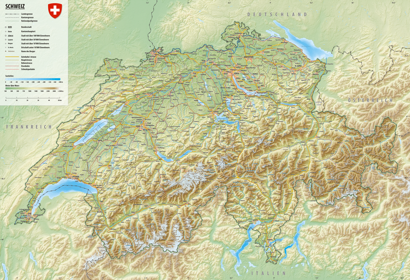
File:Reliefkarte Schweiz.png
Appearance

Size of this preview: 800 × 548 pixels. Other resolutions: 320 × 219 pixels | 640 × 438 pixels | 1,024 × 701 pixels | 1,280 × 876 pixels | 2,560 × 1,753 pixels | 10,129 × 6,935 pixels.
Original file (10,129 × 6,935 pixels, file size: 73.69 MB, MIME type: image/png)
File history
Click on a date/time to view the file as it appeared at that time.
| Date/Time | Thumbnail | Dimensions | User | Comment | |
|---|---|---|---|---|---|
| 16:05, 2 February 2019 |  | 10,129 × 6,935 (73.46 MB) | Tschubby | {{Information |description= |date= |source= |author= |permission= |other versions= }} | |
| 10:31, 24 January 2019 |  | 10,129 × 6,935 (73.45 MB) | Tschubby | {{Information |description= |date= |source= |author= |permission= |other versions= }} | |
| 10:23, 24 January 2019 |  | 10,129 × 6,935 (73.45 MB) | Tschubby | {{Information |description= |date= |source= |author= |permission= |other versions= }} | |
| 23:08, 20 January 2019 |  | 10,129 × 6,935 (73.45 MB) | Tschubby | == {{int:filedesc}} == {{Information |Description=Hauptstrassennetz der Schweiz Stand 2019 |Source={{own}} <br />Topographischer Hintergrund: [http://www2.jpl.nasa.gov/srtm NASA Shuttle Radar Topography Mission] (public domain). SRTM3 v.2. |Date=2019-01-20 |Author=Tschubby |Permission= |other_versions= }} == {{int:license-header}} == {{self|GFDL|cc-by-sa-3.0,2.5,2.0,1.0}} Category:Road maps of Switzerland | |
| 15:46, 17 January 2019 |  | 10,128 × 6,935 (73.44 MB) | Tschubby | {{Information |description= |date= |source= |author= |permission= |other versions= }} | |
| 17:50, 6 January 2018 |  | 10,131 × 6,935 (57.69 MB) | Tschubby | {{Information |Description= |Source= |Date= |Author= |Permission= |other_versions= }} | |
| 17:43, 15 December 2017 |  | 10,131 × 6,936 (57.69 MB) | Tschubby | {{Information |Description= |Source= |Date= |Author= |Permission= |other_versions= }} | |
| 13:50, 17 November 2017 |  | 10,131 × 6,935 (57.69 MB) | Tschubby | {{Information |Description= |Source= |Date= |Author= |Permission= |other_versions= }} | |
| 09:20, 2 June 2017 |  | 10,130 × 6,935 (57.68 MB) | Tschubby | {{Information |Description= |Source= |Date= |Author= |Permission= |other_versions= }} | |
| 20:18, 18 May 2017 |  | 10,130 × 6,935 (57.68 MB) | Tschubby | {{Information |Description= |Source= |Date= |Author= |Permission= |other_versions= }} |
File usage
The following 3 pages use this file:
Global file usage
The following other wikis use this file:
- Usage on af.wikipedia.org
- Usage on als.wikipedia.org
- Usage on ast.wikipedia.org
- Usage on ban.wikipedia.org
- Usage on ca.wikipedia.org
- Usage on da.wikipedia.org
- Usage on de.wikipedia.org
- Schweiz
- Portal:Schweiz
- Benutzer:Tschubby
- Portal:Schweiz/Galerie
- Wikipedia:Exzellente Bilder/Karten und Satellitenbilder
- Portal:Schweiz/Einleitung
- Portal:Schweiz/Galerie/Bilder
- Benutzer:Tschubby/Schweiz
- Geographie der Schweiz
- Wikipedia:Kandidaten für exzellente Bilder/Archiv2011/5
- Datei:Reliefkarte Schweiz.png
- Wikipedia:Kartenwerkstatt/Karte des Tages/Galerie
- Usage on dsb.wikipedia.org
- Usage on eml.wikipedia.org
- Usage on es.wikipedia.org
- Usage on fi.wikivoyage.org
- Usage on fr.wikipedia.org
- Usage on ga.wikipedia.org
- Usage on gl.wikipedia.org
- Usage on ha.wikipedia.org
- Usage on hu.wikipedia.org
- Usage on it.wikipedia.org
- Usage on ka.wikipedia.org
- Usage on lmo.wiktionary.org
- Usage on mr.wikipedia.org
- Usage on mt.wikipedia.org
- Usage on pfl.wikipedia.org
- Usage on pl.wikipedia.org
- Usage on pl.wikivoyage.org
- Usage on pt.wikipedia.org
- Usage on rm.wikipedia.org
- Usage on roa-tara.wikipedia.org
- Usage on sl.wikipedia.org
- Usage on sr.wikipedia.org
- Usage on th.wikipedia.org
- Usage on tr.wikipedia.org
- Usage on tt.wikipedia.org
- Usage on vi.wikipedia.org
- Usage on www.wikidata.org

