Brod, Bosnia and Herzegovina
Brod
Брод | |
|---|---|
Town and municipality | |
 Brod | |
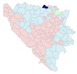
 Location of Brod within Bosnia and Herzegovina | |
 | |
| Coordinates: 45°08′N 17°59′E / 45.133°N 17.983°E | |
| Country | Bosnia and Herzegovina |
| Entity | Republika Srpska |
| Government | |
| • Mayor | Ilija Jovičić (SNSD) [1] |
| • Municipality | 229.3 km2 (88.5 sq mi) |
| Population (2013 census) | |
| • Town | 8,563 |
| • Municipality | 16,619 |
| • Municipality density | 72/km2 (190/sq mi) |
| Time zone | UTC+1 (CET) |
| • Summer (DST) | UTC+2 (CEST) |
| Area code | 53 |
| Website | www |


Brod (Serbian Cyrillic: Брод,[1] pronounced [brôːd]) is a town and municipality located in Republika Srpska, an entity of Bosnia and Herzegovina. It is situated on the south bank of the river Sava, in the western part of the Posavina region.[2] As of 2013, the town has a population of 7,637 inhabitants, while the municipality has a population of 16,619 inhabitants.
Name
Prior to the Bosnian War of the 1990s, the town was known as Bosanski Brod. During the war the prefix "Bosanski" was replaced with "Srpski" due to the town being under Serb control. In May 2009, the National Assembly of the Republika Srpska removed any prefix from the name resulting in the name Brod. Today its official name is just Brod, without either prefix Bosanski or Srpski. The Croatian town of Slavonski Brod is situated on the opposite (northern) bank of the Sava, forming a built-up area of more than 110,000 inhabitants.
The bridge over the Sava River at Brod was destroyed in the early hours of October 1992; it was rebuilt several years later after the hostilities ended.
Settlements
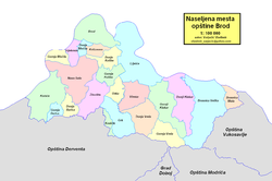
Aside from the town of Brod, the following settlements comprise the municipality:
Demographics
Population
| Population of settlements – Brod municipality | |||||||||
|---|---|---|---|---|---|---|---|---|---|
| Settlement | 1931. | 1948 | 1953. | 1961. | 1971. | 1981. | 1991. | 2013. | |
| Total | 30,115 | 32,286 | 33,744 | 16,619 | |||||
| 1 | Brod | 7,386 | 4,993 | 5,329 | 7,350 | 10,003 | 12,506 | 14,098 | 7,961 |
| 2 | Donja Močila | 659 | 226 | ||||||
| 3 | Donje Kolibe | 837 | 219 | ||||||
| 4 | Donji Klakar | 583 | 407 | ||||||
| 5 | Gornja Močila | 717 | 220 | ||||||
| 6 | Gornje Kolibe | 1,407 | 723 | ||||||
| 7 | Gornji Klakar | 755 | 433 | ||||||
| 8 | Grk | 559 | 258 | ||||||
| 9 | Koraće | 2,022 | 1,151 | ||||||
| 10 | Liješće | 2,032 | 1,518 | ||||||
| 11 | Novo Selo | 2,953 | 982 | ||||||
| 12 | Sijekovac | 1,551 | 455 | ||||||
| 13 | Vinska | 561 | 282 | ||||||
| 14 | Zborište | 854 | 381 | ||||||
Ethnic composition
| Ethnic composition – Brod town | |||||||
|---|---|---|---|---|---|---|---|
| Nationality | 2013. | 1991. | 1981. | 1971. | |||
| Total | 7,961 (100,0%) | 14,098 (100,0%) | 12,506 (100,0%) | 10,003 (100,0%) | |||
| Serbs | 6,767 (85,00%) | 4,373 (31,02%) | 3,505 (28,03%) | 3,229 (32,28%) | |||
| Bosniaks | 521 (6,544%) | 2,246 (15,93%) | 1,682 (13,45%) | 2,093 (20,92%) | |||
| Croats | 404 (5,075%) | 4,086 (28,98%) | 3,812 (30,48%) | 4,166 (41,65%) | |||
| Others | 269 (3,379%) | 633 (4,490%) | 48 (0,384%) | 86 (0,860%) | |||
| Yugoslavs | 2 760 (19,58%) | 3,406 (27,23%) | 376 (3,759%) | ||||
| Montenegrins | 25 (0,200%) | 24 (0,240%) | |||||
| Slovenes | 10 (0,080%) | 10 (0,100%) | |||||
| Macedonians | 8 (0,064%) | 3 (0,030%) | |||||
| Albanians | 6 (0,048%) | 3 (0,030%) | |||||
| Hungarians | 4 (0,032%) | 12 (0,120%) | |||||
| Roma | 1 (0,010%) | ||||||
| Ethnic composition – Brod municipality | |||||||
|---|---|---|---|---|---|---|---|
| Nationality | 2013. | 1991. | 1981. | 1971. | |||
| Total | 16,619 (100,0%) | 34,138 (100,0%) | 32,286 (100,0%) | 30,115 (100,0%) | |||
| Serbs | 11,477 (69,06%) | 11,389 (33,36%) | 10,737 (33,26%) | 11,273 (37,43%) | |||
| Croats | 3,287 (19,78%) | 13,993 (40,99%) | 13,579 (42,06%) | 14,489 (48,11%) | |||
| Bosniaks | 1,509 (9,080%) | 4,088 (11,97%) | 3,106 (9,620%) | 3,706 (12,31%) | |||
| Others | 346 (2,082%) | 1 004 (2,941%) | 89 (0,276%) | 146 (0,485%) | |||
| Yugoslavs | 3,664 (10,73%) | 4,704 (14,57%) | 436 (1,448%) | ||||
| Montenegrins | 28 (0,087%) | 30 (0,100%) | |||||
| Macedonians | 15 (0,046%) | 3 (0,010%) | |||||
| Slovenes | 11 (0,034%) | 13 (0,043%) | |||||
| Albanians | 11 (0,034%) | 3 (0,010%) | |||||
| Hungarians | 6 (0,019%) | 15 (0,050%) | |||||
| Roma | 1 (0,003%) | ||||||
Administrative areas
The Municipality of Brod according to population census from 1991, had twenty-three inhabited settlements, divided into twelve local communities:
City local communities
- MZ Brodsko Polje 1
- MZ Brodsko Polje 2
- MZ Brod - downtown
- MZ Karađorđevo
- MZ Rit
- MZ Tulek
Rural communities
- MZ Gornji Klakar
- MZ Donji Klakar
- MZ Gornje Kolibe
- MZ Donje Kolibe
- MZ Koraće
- MZ Liješće
- MZ Novo Selo
- MZ Sijekovac
- MZ Vinska
- MZ Unka
- MZ Gornja Vrela
- MZ Grk
- MZ Barica[3]
Notable residents
- Duško Trifunović, children's writer and poet
- Sead Mašić, football player
- Edin Mujčin, football player
- Ljupko Petrović, football coach
- Zdravko Zovko, handball coach
See also
References
- ^ The official web site of the municipality Archived 2013-11-26 at the Wayback Machine, Brod/Брод.
- ^ The official name of region Archived 2015-06-07 at the Wayback Machine
- ^ "Archived copy". Archived from the original on 2014-08-21. Retrieved 2014-08-21.
{{cite web}}: CS1 maint: archived copy as title (link)
Sources
- Mangold, Max (2005), Das Aussprachewörterbuch, Duden, ISBN 9783411040667


