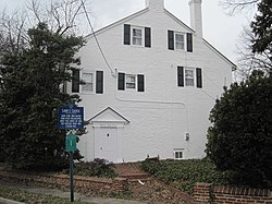
Ladd's Castle
Appearance
Ladd's Castle | |
 | |
| Location | 1337 Lafayette Avenue, Colonial Manor, New Jersey |
|---|---|
| Coordinates | 39°51′28″N 75°8′37″W / 39.85778°N 75.14361°W |
| Area | 1 acre (0.40 ha) |
| Built | ca. 1688 |
| NRHP reference No. | 72000794[1] |
| NJRHP No. | 1425[2] |
| Significant dates | |
| Added to NRHP | October 31, 1972 |
| Designated NJRHP | March 15, 1972 |
Ladd's Castle (also known as Candor Hall) is a historic building at 1337 Lafayette Avenue in the Colonial Manor section of West Deptford Township, Gloucester County, New Jersey, United States.
It was built around 1688 by William Ladd, a surveyor who purportedly helped William Penn to plan out Philadelphia.[3] The building was added to the National Register of Historic Places in 1972.
See also
- List of the oldest buildings in New Jersey
- National Register of Historic Places listings in New Jersey
References
- ^ "National Register Information System". National Register of Historic Places. National Park Service. March 13, 2009.
- ^ "New Jersey and National Registers of Historic Places - Gloucester County" (PDF). New Jersey Department of Environmental Protection - Historic Preservation Office. April 1, 2010. p. 5. Archived from the original (PDF) on August 18, 2011. Retrieved October 7, 2010.
- ^ Lee, Francis Bazley (1910-01-01). Genealogical and Memorial History of the State of New Jersey ... Lewis historical publishing Company. p. 746.
Categories:
- Houses completed in 1688
- Houses on the National Register of Historic Places in New Jersey
- Houses in Gloucester County, New Jersey
- National Register of Historic Places in Gloucester County, New Jersey
- West Deptford Township, New Jersey
- New Jersey Register of Historic Places
- 1688 establishments in New Jersey
- New Jersey Registered Historic Place stubs


