Moreni
Appearance
Moreni | |
|---|---|
 | |
 Location in Dâmbovița County | |
| Coordinates: 44°58′49″N 25°38′40″E / 44.98028°N 25.64444°E | |
| Country | Romania |
| County | Dâmbovița |
| Government | |
| • Mayor (2020–2024) | Constantin Dinu[1] (PSD) |
Area | 35.14 km2 (13.57 sq mi) |
| Elevation | 240 m (790 ft) |
| Population (2021-12-01)[2] | 15,472 |
| • Density | 440/km2 (1,100/sq mi) |
| Time zone | EET/EEST (UTC+2/+3) |
| Postal code | 135300 |
| Vehicle reg. | DB |
| Website | www |
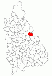
Moreni (Template:IPA-ro) is a municipality in Dâmbovița County, Muntenia, Romania, with a population of 22,868. The city is in the eastern part of the county, on the border with Prahova County. It is located 22 km (14 mi) east of the county seat, Târgoviște, and about 100 km (62 mi) north-west of Bucharest.

History
| Year | Pop. | ±% |
|---|---|---|
| 1948 | 9,046 | — |
| 1956 | 11,687 | +29.2% |
| 1966 | 11,659 | −0.2% |
| 1977 | 17,737 | +52.1% |
| 1992 | 22,886 | +29.0% |
| 2002 | 22,868 | −0.1% |
| 2011 | 18,687 | −18.3% |
| Source: Census data | ||
In 1861, Moreni became the first place in Romania (and third in the world) where oil was extracted.[3]
Recently, an industrial park was built by the local authorities to encourage investment in the area.
Natives
- Gheorghe Barbu
- Constantin Herold
- Andrei Ivan
- Ralph S. Locher
- George Mihăiță
- Ștefan Niculescu
- Gabriel Paraschiv
- Ionuț Zaharia
References
- ^ "Results of the 2020 local elections". Central Electoral Bureau. Retrieved 8 June 2021.
- ^ "Populaţia rezidentă după grupa de vârstă, pe județe și municipii, orașe, comune, la 1 decembrie 2021" (XLS). National Institute of Statistics.
- ^ ANRM - prezentare generală a resurselor petroliere
External links
Wikimedia Commons has media related to Moreni.


