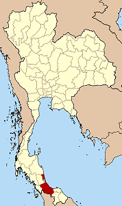
Songkhla province
Appearance
| Statistics | |
|---|---|
| Capital: | Songkhla |
| Area: | 7,393.9 km² Ranked 26th |
| Inhabitants: | 1,249,402 (2001) Ranked 12th |
| pop. density: | 169 inh./km² Ranked 15th |
| Map | |
 | |
Songkhla (thai สงขลา) is the one of the southern provinces (changwat) of Thailand. Neighboring provinces are (from east clockwise) Satun, Trang, Phattalung, Pattani and Yala. To the south it borders Malaysia.
Geography
The province is located on the Malay Peninsula, at the coast of the Gulf of Thailand. The highest elevation is the Khao Mai Kaeo with 821 meters.
Demographics
23.2% of the population are muslim, 4.6% are from the Malayan minority.
Symbols
| Provincial seal |
The provincial seal shows a conch-shell on a tray with glas decorations. The origin of the conch-shell is unclear, the most widely adopted interpretation is that it was a decoration on the jacket of the Prince of Songkhla. Provincial tree is Azardirachta excelsa. |
Administrative divisions
| Amphoe (districts) | |
|---|---|
|
|
