Kamýk nad Vltavou
Appearance
Kamýk nad Vltavou | |
|---|---|
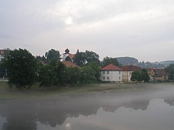
 Left bank of the Vltava River in Kamýk | |
| Coordinates: 49°38′21″N 14°15′13″E / 49.63917°N 14.25361°E | |
| Country | |
| Region | Central Bohemian |
| District | Příbram |
| First mentioned | 1285 |
| Area | |
• Total | 11.89 km2 (4.59 sq mi) |
| Elevation | 274 m (899 ft) |
| Population (2021-01-01)[1] | |
• Total | 951 |
| • Density | 80/km2 (210/sq mi) |
| Time zone | UTC+1 (CET) |
| • Summer (DST) | UTC+2 (CEST) |
| Postal code | 262 63 |
| Website | www |
Kamýk nad Vltavou is a municipality and village in Příbram District in the Central Bohemian Region of the Czech Republic. It has about 1,000 inhabitants. It lies on the Vltava river.
Administrative parts
Village of Velká is an administrative part of Kamýk nad Vltavou.
History
The first written mention about the Vrškamýk Castle is from 1236 and about the settlements above the castle (Starý Kamýk and Nový Kamýk) from 1285.[2]
References
- ^ "Population of Municipalities – 1 January 2021". Czech Statistical Office. 2021-04-30.
- ^ "Dějiny obce Kamýk nad Vltavou" (in Czech). Obec Kamýk nad Vltavou. Retrieved 2020-11-08.
Wikimedia Commons has media related to Kamýk nad Vltavou.


