Čelić
Appearance
Čelić
Челић | |
|---|---|
Town and municipality | |
 | |
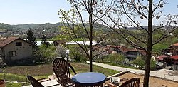
 Location of Čelić (unfinished pool in the background) | |
| Coordinates: 44°43′N 18°49′E / 44.717°N 18.817°E | |
| Country | |
| Entity | Federation of Bosnia and Herzegovina |
| Canton | |
| Geographical region | Semberija |
| Government | |
| • Municipality mayor | Admir Hrustanović (SBiH) |
| Area | |
• Total | 140 km2 (50 sq mi) |
| Population (2013 census) | |
• Total | 12,083 |
| • Density | 86/km2 (220/sq mi) |
| Time zone | UTC+1 (CET) |
| • Summer (DST) | UTC+2 (CEST) |
| Area code | +387 35 |
| Website | www |
Čelić (Serbian Cyrillic: Челић) is a town and municipality located in Tuzla Canton of the Federation of Bosnia and Herzegovina, an entity of Bosnia and Herzegovina. Čelić was part of the municipality of Lopare prior to the war in Bosnia and Herzegovina. The part of the municipality that was controlled by the Army of the Republic of Bosnia and Herzegovina became the municipality of Čelić.
Geography
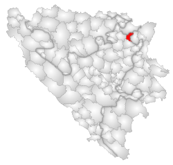
The municipality is 132 km2 (51 sq mi) with a population of 12,000. It is located in the hills of Majevica. Čelić borders the municipalities of Srebrenik, Tuzla, Lopare (RS) and the Brčko District.
Demographics
According to the 2013 census results, the municipality of Čelić has 12,083 inhabitants.
Ethnic groups
The ethnic composition of the municipality:
| Municipality | Nationality | Total
| |||||
|---|---|---|---|---|---|---|---|
Bosniaks
|
%
|
Croats
|
%
|
Serbs
|
%
| ||
| Čelić | 9,341 |
88.94
|
843 |
8.02
|
192 |
1.82
|
10,502
|
References
External links
Wikimedia Commons has media related to Čelić Municipality.


