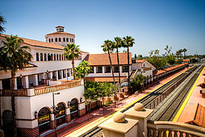
Santa Ana Regional Transportation Center
Santa Ana | |||||||||||||
|---|---|---|---|---|---|---|---|---|---|---|---|---|---|
 Santa Ana station, 2008 | |||||||||||||
| General information | |||||||||||||
| Other names | Santa Ana Regional Transportation Center | ||||||||||||
| Location | 1000 E. Santa Ana Blvd Santa Ana, California 92701 | ||||||||||||
| Coordinates | 33°45′06″N 117°51′23″W / 33.7516°N 117.8565°W | ||||||||||||
| Owned by | City of Santa Ana[1] | ||||||||||||
| Line(s) | SCRRA Orange Subdivision[2] | ||||||||||||
| Platforms | 2 side platforms | ||||||||||||
| Tracks | 2 | ||||||||||||
| Train operators | Metrolink and Amtrak | ||||||||||||
| Connections | Greyhound, OCTA, International Bus Lines | ||||||||||||
| Construction | |||||||||||||
| Parking | 315 spaces | ||||||||||||
| Accessible | Yes | ||||||||||||
| Architect | The Blurock Partnership | ||||||||||||
| Architectural style | Mediterranean Revival/Spanish Colonial Revival | ||||||||||||
| Other information | |||||||||||||
| Station code | SNA | ||||||||||||
| History | |||||||||||||
| Opened | September 7, 1985[3] | ||||||||||||
| Passengers | |||||||||||||
| 2017 | 194,581[4] | ||||||||||||
| Services | |||||||||||||
|
Lua error in Module:Adjacent_stations at line 237: Unknown line "Inland Empire-Orange County". | |||||||||||||
| |||||||||||||
| |||||||||||||
Santa Ana Regional Transportation Center is a passenger rail station and transportation center in Santa Ana, California. It is used by Amtrak's Pacific Surfliner and Metrolink's Orange County Line and Inland Empire-Orange County Line trains. It is also a Greyhound station and a hub for the Orange County Transportation Authority bus system as well as a terminal for several Mexican bus tour companies.
History
When the station opened on September 7, 1985, it was the largest new rail station built in the United States since the completion of the New Orleans Union Passenger Terminal circa 1955.[citation needed] The center was erected on the site of a former Atchison, Topeka and Santa Fe Railway combination depot that had been constructed in 1939 and closed in 1982.[5][failed verification] The station, which cost approximately $17 million, was funded by the U.S. Department of Transportation, California Department of Transportation, and the city of Santa Ana.[6]
Future service
Santa Ana Regional Transportation Center is the planned eastern terminus of the OC Streetcar, a 4-mile (6.4 km) streetcar line to Garden Grove that is scheduled to open in 2023.
Design

The station was designed by the Blurock Partnership architectural firm in the Spanish Colonial Revival and Mediterranean Revival architectural styles to complement the region's older buildings. Features include red barrel roof tiles, arcades, colonnades, exterior walls finished to resemble stucco, and the extensive use of painted tiles for decoration.[6]
Layout
| Track 1 (northbound) | ■ Pacific Surfliner | toward San Luis Obispo (Anaheim) |
| ■ Inland Empire–Orange County Line | toward San Bernardino-Downtown (Orange) | |
| ■ Orange County Line | toward L.A. Union Station (Orange) | |
| Track 2 (southbound) | ■ Pacific Surfliner | toward San Diego Union Station (Irvine) |
| ■ Inland Empire–Orange County Line | toward Oceanside (Tustin) | |
| ■ Orange County Line | toward Oceanside (Tustin) |
In popular culture
In FY2010 Santa Ana was the 22nd-busiest of Amtrak's 73 California stations, boarding or detraining an average of about 420 passengers daily.[7]
Notes
- ^ Cite error: The named reference
LATFeb96was invoked but never defined (see the help page). - ^ SMA Rail Consulting (April 2016). "California Passenger Rail Network Schematics" (PDF). California Department of Transportation.
- ^ Rose, Andy (September 8, 1985). "Santa Ana : Officials Dedicate Transportation Center". Los Angeles Times. Retrieved 19 December 2015.
- ^ "Amtrak Fact Sheet, Fiscal Year 2017 - State of California" (PDF). Amtrak. November 2017. Retrieved 2018-01-06.
- ^ Gustafson and Serpico, p. 189
- ^ a b Great American Stations. Accessed March 12, 2013.
- ^ "Amtrak Fact Sheet, FY2010, State of California" (PDF). Amtrak. November 2010. Retrieved 2011-01-06.
References
- Gustafson, Lee and Phil Serpico (1974). Santa Fe Coast Lines Depots: Los Angeles Division. Omni Publications, Palmdale, CA. ISBN 0-88418-003-4.
- Internet Movie Database
External links
- Amtrak stations in Orange County, California
- Metrolink stations in Orange County, California
- Former Atchison, Topeka and Santa Fe Railway stations in California
- Transit centers in the United States
- Buildings and structures in Santa Ana, California
- Transportation in Santa Ana, California
- Mediterranean Revival architecture in California
- Spanish Colonial Revival architecture in California
- Railway stations in the United States opened in 1985
- Railway stations in the United States opened in 1939
- 1939 establishments in California
- 1985 establishments in California
- Railway stations closed in 1982
- 1982 disestablishments in California
- Bus stations in Orange County, California

