Calvörde
Calvörde | |
|---|---|
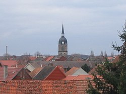
 Over the rooftops of Calvörde | |
| Country | Germany |
| State | Saxony-Anhalt |
| District | Ohrekreis |
| Municipal assoc. | Oebisfelde-Calvörde |
| Government | |
| • Mayor | Klaus Zimmermann (CDU) |
| Area | |
• Total | 36.24 km2 (13.99 sq mi) |
| Elevation | 52 m (171 ft) |
| Population (2006-06-30) | |
• Total | 1,780 |
| • Density | 49/km2 (130/sq mi) |
| Time zone | UTC+01:00 (CET) |
| • Summer (DST) | UTC+02:00 (CEST) |
| Postal codes | 39359 |
| Dialling codes | 039051 |
| Vehicle registration | OK |
| Website | www.calvoerde.de |
Calvörde ( [kalˈføːʁdə]) is a municipality in Saxony-Anhalt, Germany. It is situated approx. 15 km northwest from Haldensleben between the Ohre river and the Midland Canal. Calvörde is part of the Verwaltungsgemeinschaft ("collective municipality") Oebisfelde-Calvörde. Before 1944 the Amt of Calvörde was part of the Duchy of Brunswick.
The first documentary mention goes back to the year 1196. At the place, where today still is a bridge, was a ford through the Ohre river. A trade route which came from southeast crossed the river here. It led from Leipzig across Magdeburg to Lüneburg and Hamburg. There also was a second road which came from Braunschweig. The emergence of the ford is attributed to a man named Kale. That's why the historic meaning of "Calvörde" is Kale's ford.
52°23′44″N 11°17′48″E / 52.39556°N 11.29667°E Coordinates: Extra unexpected parameters


