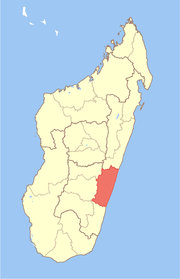
Fitovinany
Appearance
Fitovinany | |
|---|---|
Region | |
 Location in Madagascar | |
| Country | |
| Capital | Manakara |
| Government | |
| • Gouveneur | Lucien Laurel Razafitsotra |
| Area | |
• Total | 19,605 km2 (7,570 sq mi) |
| Population (2018)[2] | |
• Total | 730,207 |
| • Density | 37/km2 (96/sq mi) |
| Time zone | UTC3 (EAT) |
Fitovinany is a region located in southeast Madagascar. Its capital is Manakara. It is inhabited by the Antemoro people.
It formerly belonged to the region Vatovavy-Fitovinany that was split on 16.06.2021 to become the regions Vatovavy and Fitovinany.[3]
The region extends along the southern part of the east coast of Madagascar. It is bordered by Vatovavy (North), Amoron'i Mania and Haute Matsiatra (West) and Atsimo-Atsinanana (South).
Administrative divisions
Fitovinany region is divided into three districts.
Districts transferred to Vatovavy:
Transportation
- Car, Taxi-Brousse
- One airport and one seaport:
- Manakara Airport
- Manakara seaport is only used for transshipments and transit (Lychee, coffee, ...)
Protected areas
- Part of Fandriana-Vondrozo Corridor
- Part of Marolambo National Park
- Part of Ranomafana National Park (Vatovavy)
References
- ^ Ralison, Eliane; Goossens, Frans. "Madagascar: Profil des marchés pour les évaluations d'urgence de la sécurité alimentaire" (PDF) (in French). Programme Alimentaire Mondial, Service de l’Evaluation des besoins d’urgence (ODAN). Retrieved 2008-03-01.
- ^ "Troisieme Recensement General de la Population et de L'Habitation (RGPH-3) Resultats Provisoires" (PDF). Institut National de la Statistique Madagascar. Retrieved May 23, 2020.
- ^ Découpage Territorial - L'Express.mg
22°08′42″S 48°00′36″E / 22.14500°S 48.01000°E

