Westside, Gibraltar
Appearance
Westside | |
|---|---|
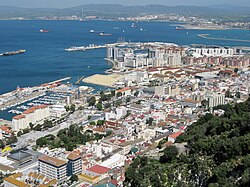
 Westside as seen from the Rock of Gibraltar. | |
 | |
| Coordinates: 36°08′35″N 5°21′17″W / 36.14306°N 5.35472°W | |
| Sovereign state | |
| Overseas Territory | |
| Population (2012) | |
• Total | 26,572 |
| Time zone | UTC+1 (CET) |
| • Summer (DST) | UTC+2 (CEST) |
| Postcode areas | GX11 1AA |
Westside is the largest city and de facto capital of Gibraltar. It lies between the western slopes of the Rock of Gibraltar and the eastern shores of the Bay of Gibraltar. In 2012 it was inhabited by 26,572 people and contained over 98% of the territory's population.[1]
Division
The city is divided into six Major Residential Areas: North District, Reclamation Areas, Sandpits, South District, Town Area, and Upper Town.[1]
Demographics
| Residential area | Population 2012[1] | Population 2001[2] |
|---|---|---|
| North District | 4,267 | 4,116 |
| Reclamation Areas | 13,356 | 9,599 |
| Sandpits | 2,053 | 2,207 |
| South District | 5,681 | 4,257 |
| Town Area | 3,264 | 3,588 |
| Upper Town | 2,457 | 2,805 |

