Shoranur
Shoranur | |
|---|---|
Town | |
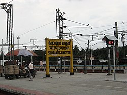
 Shoranur Junction railway station, the largest railway station in the state in terms of area. | |
| Coordinates: 10°46′N 76°17′E / 10.77°N 76.28°E | |
| Country | India |
| State | Kerala |
| District | Palakkad |
| Government | |
| • Body | Municipality |
| • Chairperson | M. K. Jayaprakash (Ward 29, CPM) |
| Area | |
• Total | 32.28 km2 (12.46 sq mi) |
| Elevation | 49 m (161 ft) |
| Population (2011) | |
• Total | 43,533 |
| • Density | 1,300/km2 (3,500/sq mi) |
| Languages | |
| • Official | Malayalam, English |
| Time zone | UTC+5:30 (IST) |
| PIN | 679121 |
| Telephone code | 0466 |
| Sex ratio | 1000:1096 ♂/♀ |
| Website | www |
Shoranur is a town and a municipality located in the Palakkad district, in the Indian state of Kerala, located on the banks of the Bharathapuzha River. The town covers an area of 32.28 km2.
Geography
Shoranur is located at 10°46′N 76°17′E / 10.77°N 76.28°E.[1] It has an average elevation of 49 metres (160 feet).
History
This place was originally a part of the Nedunganad Swaroopam dynasty, which was ruled by the Nedungadis, who sway over a large part of present-day Pattambi and Ottapalam Taluks.[2] By the end of the 15th century CE, Nedunganad came under the leadership of the Zamorin of Calicut, who was also the main ruler of South Malabar region.[2] The Zamorin appointed his local chieftain at Kavalappara Kovilakam to rule this area.[2] It was a part of Walluvanad Taluk in Malappuram Revenue Division of Malabar District during British Raj, with the Taluk headquarters at Perinthalmanna.[2]
Politics
Shornur became a municipality in 1978 and is divided into 33 electoral wards. It is a part of Shornur Legislative Assembly Constituency and Palakkad Parliamentary Constituency.[3] Shornur assembly constituency was formed in 2011. Before that Shornur municipality was under Pattambi assembly constituency.
Educational institutions
- Institute Of Printing Technology & Government Polytechnic College, Shoranur
- Institute For Communicative And Cognitive Neurosciences, Kavalapara, Shoranur
- Vishnu Ayurveda College, Kulapully, Shoranur
- MPMMSN Trust College, Shoranur
- Carmel CMI School, Shoranur
- Al Ameen Engineering College
- Jyoti engineering college, Cheruthuruthy
- National Research Institute for Panchakarma, Cheruthuruthy
Notable people
- Balan K. Nair, actor
- Meghanathan, actor
See also
References
- ^ Falling Rain Genomics, Inc - Shoranur
- ^ a b c d Logan, William (2010). Malabar Manual (Volume-I). New Delhi: Asian Educational Services. pp. 631–666. ISBN 9788120604476.
- ^ maps of india - shornur assembly constituency


