Valentine, Texas
Valentine, Texas | |
|---|---|
 | |
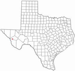
 Location of Valentine, Texas | |
 | |
| Coordinates: 30°35′15″N 104°29′44″W / 30.58750°N 104.49556°W | |
| Country | United States |
| State | Texas |
| County | Jeff Davis |
| Government | |
| Area | |
• Total | 0.49 sq mi (1.26 km2) |
| • Land | 0.49 sq mi (1.26 km2) |
| • Water | 0.00 sq mi (0.00 km2) |
| Elevation | 4,432 ft (1,351 m) |
| Population (2010) | |
• Total | 134 |
• Estimate (2019)[2] | 133 |
| • Density | 273.66/sq mi (105.70/km2) |
| Time zone | UTC-6 (Central (CST)) |
| • Summer (DST) | UTC-5 (CDT) |
| ZIP code | 79854 |
| Area code | 432 |
| FIPS code | 48-74648[3] |
| GNIS feature ID | 1370547[4] |
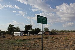
Valentine is a town in Jeff Davis County, Texas, United States. The population was 134 at the 2010 census,[5] down from 187 at the 2000 census. It is the only incorporated municipality in Jeff Davis County. Its name refers to the date of its founding in 1882 by a Southern Pacific Railroad construction crew: February 14. It is one of several cities named Valentine in the United States where the U.S. Postal Service cancels envelopes for Valentine's Day.[6]
The noted art installation Prada Marfa (2005) is located 1.5 miles (2.4 km) northwest of Valentine on U.S. 90. The Valentine resident and artist Boyd Elder (1944-2018) served as its caretaker.[7]
The John Wayne film Cahill U.S. Marshal, filmed in Durango, Mexico, was set in Valentine, Texas.
Geography
Valentine is located in western Jeff Davis County at 30°35′15″N 104°29′44″W / 30.58750°N 104.49556°W (30.587504, -104.495498),[8] along U.S. Route 90. The highway leads northwest 38 miles (61 km) to Interstate 10 at Van Horn, and southeast 35 miles (56 km) to Marfa.
According to the United States Census Bureau, the town has a total area of 0.49 square miles (1.26 km2), all land.[5] The town sits in a flat basin between the Davis Mountains 15 miles (24 km) to the east and the Sierra Vieja 11 miles (18 km) to the west.
Demographics
| Census | Pop. | Note | %± |
|---|---|---|---|
| 1890 | 100 | — | |
| 1900 | 140 | 40.0% | |
| 1910 | 300 | 114.3% | |
| 1920 | 250 | −16.7% | |
| 1930 | 629 | 151.6% | |
| 1940 | 499 | −20.7% | |
| 1950 | 510 | 2.2% | |
| 1960 | 420 | −17.6% | |
| 1970 | 213 | −49.3% | |
| 1980 | 328 | 54.0% | |
| 1990 | 217 | −33.8% | |
| 2000 | 187 | −13.8% | |
| 2010 | 134 | −28.3% | |
| 2019 (est.) | 133 | [2] | −0.7% |
| U.S. Decennial Census[9] | |||
As of the census[3] of 2000, there were 187 people, 72 households, and 55 families residing in the town. The population density was 388.8 people per square mile (150.4/km2). There were 138 housing units at an average density of 286.9 per square mile (111.0/km2). The racial makeup of the town was 89.84% White, 0.53% African American, 8.02% from other races, and 1.60% from two or more races. Hispanic or Latino of any race were 58.82% of the population.
There were 72 households, out of which 33.3% had children under the age of 18 living with them, 65.3% were married couples living together, 2.8% had a female householder with no husband present, and 23.6% were non-families. 22.2% of all households were made up of individuals, and 13.9% had someone living alone who was 65 years of age or older. The average household size was 2.60 and the average family size was 3.04.
In the town, the population was spread out, with 25.7% under the age of 18, 3.7% from 18 to 24, 24.6% from 25 to 44, 25.1% from 45 to 64, and 20.9% who were 65 years of age or older. The median age was 42 years. For every 100 females, there were 103.3 males. For every 100 females age 18 and over, there were 104.4 males.
The median income for a household in the town was $34,375, and the median income for a family was $38,750. Males had a median income of $22,031 versus $33,333 for females. The per capita income for the town was $16,136. About 12.8% of families and 10.7% of the population were below the poverty line, including 13.2% of those under the age of eighteen and none of those 65 or over.
Climate
Valentine experiences a semi-arid climate (Köppen BSk) with cool, dry winters and hot, dry summers.
- Coordinates: 30°35′27″N 104°29′29″W / 30.59083°N 104.49139°W
- Elevation: 4,440 feet (1,353 m)[10]
| Climate data for Valentine, Texas (1991-2020) | |||||||||||||
|---|---|---|---|---|---|---|---|---|---|---|---|---|---|
| Month | Jan | Feb | Mar | Apr | May | Jun | Jul | Aug | Sep | Oct | Nov | Dec | Year |
| Record high °F (°C) | 83 (28) |
87 (31) |
91 (33) |
98 (37) |
102 (39) |
108 (42) |
106 (41) |
103 (39) |
100 (38) |
96 (36) |
86 (30) |
80 (27) |
108 (42) |
| Mean daily maximum °F (°C) | 60.8 (16.0) |
66.3 (19.1) |
73.3 (22.9) |
81.1 (27.3) |
88.6 (31.4) |
94.5 (34.7) |
92.3 (33.5) |
91.4 (33.0) |
86.6 (30.3) |
79.9 (26.6) |
69.3 (20.7) |
61.1 (16.2) |
78.8 (26.0) |
| Daily mean °F (°C) | 44.1 (6.7) |
48.5 (9.2) |
54.8 (12.7) |
62.3 (16.8) |
70.5 (21.4) |
77.9 (25.5) |
77.9 (25.5) |
76.8 (24.9) |
71.7 (22.1) |
63.2 (17.3) |
51.9 (11.1) |
44.7 (7.1) |
62.0 (16.7) |
| Mean daily minimum °F (°C) | 27.4 (−2.6) |
30.7 (−0.7) |
36.3 (2.4) |
43.5 (6.4) |
52.4 (11.3) |
61.3 (16.3) |
63.5 (17.5) |
62.3 (16.8) |
56.8 (13.8) |
46.5 (8.1) |
34.6 (1.4) |
28.3 (−2.1) |
45.3 (7.4) |
| Record low °F (°C) | 3 (−16) |
−7 (−22) |
12 (−11) |
21 (−6) |
31 (−1) |
43 (6) |
51 (11) |
50 (10) |
39 (4) |
17 (−8) |
8 (−13) |
0 (−18) |
−7 (−22) |
| Average precipitation inches (mm) | 0.63 (16) |
0.43 (11) |
0.37 (9.4) |
0.36 (9.1) |
0.71 (18) |
1.76 (45) |
2.40 (61) |
1.36 (35) |
1.75 (44) |
1.20 (30) |
0.57 (14) |
0.58 (15) |
12.12 (307.5) |
| Average snowfall inches (cm) | 1.1 (2.8) |
0.0 (0.0) |
0.0 (0.0) |
0.0 (0.0) |
0.0 (0.0) |
0.0 (0.0) |
0.0 (0.0) |
0.0 (0.0) |
0.0 (0.0) |
0.0 (0.0) |
0.1 (0.25) |
0.3 (0.76) |
1.5 (3.8) |
| Average precipitation days (≥ 0.001 in) | 2.59 | 2.19 | 2.06 | 1.63 | 3.77 | 6.19 | 7.21 | 5.06 | 4.19 | 4.00 | 1.94 | 2.56 | 43.39 |
| Source 1: Weather Atlas[11] | |||||||||||||
| Source 2: Western Regional Climate Center, Desert Research Institute[12] | |||||||||||||
Government and infrastructure
The United States Postal Service operates the Valentine Post Office.[13] On Valentine's Day many people send postcards to Valentine, Texas. In July 2011 the USPS announced that the post office may close.[14]
Entertainment

Valentine is home to, as one politician puts it, "the greatest ever West Texas Valentine's Day celebration." Hosted by the Big Bend Brewing Company of Alpine, Texas, as many as 1,000 people invade Valentine on Valentine's Day from points as close as Valentine itself, Marfa, and Alpine, to far away places such as Chicago and Cleveland. In 2014, the west Texas brewery served free cups of beer while Gary P. Nunn played live on stage, under the moonlit night and stars.[15]
Earthquake
On August 16, 1931, a magnitude 5.8 earthquake struck near Valentine, causing extensive damage. The earthquake was the most powerful ever recorded in Texas.[16]
References
- ^ "2019 U.S. Gazetteer Files". United States Census Bureau. Retrieved August 7, 2020.
- ^ a b "Population and Housing Unit Estimates". United States Census Bureau. May 24, 2020. Retrieved May 27, 2020.
- ^ a b "U.S. Census website". United States Census Bureau. Retrieved 2008-01-31.
- ^ "US Board on Geographic Names". United States Geological Survey. 2007-10-25. Retrieved 2008-01-31.
- ^ a b "Geographic Identifiers: 2010 Census Summary File 1 (G001): Valentine town, Texas". American Factfinder. U.S. Census Bureau. Archived from the original on February 13, 2020. Retrieved December 7, 2018.
- ^ Rodriguez, Lois M. (February 3, 2014). "From Valentine, With Love". Texas Highways. Archived from the original on December 22, 2017. Retrieved 2017-12-19.
- ^ Cohen, Alina (May 25, 2018). "The Fake Prada Store in the Texas Desert That Became an Art Mecca". Artsy.
- ^ "US Gazetteer files: 2010, 2000, and 1990". United States Census Bureau. 2011-02-12. Retrieved 2011-04-23.
- ^ "Census of Population and Housing". Census.gov. Retrieved June 4, 2015.
- ^ "US COOP Station Map". Western Regional Climate Center, Desert Research Institute. Retrieved May 3, 2015.
- ^ "Valentine, Texas, USA - Monthly weather forecast and Climate data". NOAA. Retrieved 26 October 2021.
- ^ "VALENTINE, TEXAS (419270), Period of Record Monthly Climate Summary". Western Regional Climate Center, Desert Research Institute. Retrieved May 3, 2015.
- ^ "Post Office™ Location - VALENTINE." United States Postal Service. Retrieved on July 26, 2011. "311 W CALIFORNIA AVE VALENTINE, TX"
- ^ Weisman, Laura. "Nine Houston post offices marked for closure (with poll)." Houston Chronicle. July 26, 2011. Retrieved on July 26, 2011.
- ^ "Ramón Rentería: Valentine had its day on Valentine's Day". Retrieved 2014-02-17.
- ^ "Historic Earthquakes: Near Valentine, Texas". United States Geological Survey. 2009-01-30. Retrieved 2010-01-15.
External links
- Handbook of Texas Online article
- West Texas Weekly, a local weekly newspaper

