Jump to content

List of airports in Guyana

From Wikipedia, the free encyclopedia

This is an old revision of this page, as edited by KittenKlub (talk | contribs) at 08:56, 30 November 2021 (completing list using gcmap). The present address (URL) is a permanent link to this revision, which may differ significantly from the current revision.

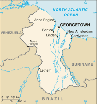
Map of Guyana

This is a list of airports in Guyana, sorted by location.

Guyana, officially the Co-operative Republic of Guyana and previously known as British Guiana, is a state on the northern coast of South America. Guyana is bordered to the east by Suriname, to the south and southwest by Brazil, to the west by Venezuela, and to the north by the Atlantic Ocean. It is the only state of the Commonwealth of Nations on mainland South America. Guyana is also a member of the Caribbean Community (CARICOM), which has its secretariat headquarters in Guyana's capital, Georgetown.

Airports

Airport names shown in bold have scheduled passenger service on commercial airlines.

City served / location Region ICAO IATA Airport name Comments
Aishalton Upper Takutu-Upper Essequibo SYAH AHL Aishalton Airport [1]
Annai Upper Takutu-Upper Essequibo SYAN NAI Annai Airport [1]
Apoteri Upper Takutu-Upper Essequibo SYAP Apoteri Airport [1]
Awaruwaunau (Awaruwaunawa) Upper Takutu-Upper Essequibo SYAW Awaruwaunau Airport [1]
Baramita Barima-Waini SYBR BMJ Baramita Airport [1]
Bartica Cuyuni-Mazaruni SYBT GFO Bartica Airport [1]
Barima-Waini SYBE BCG Bemichi Airport [1]
Ebini Upper Demerara-Berbice SYEB Ebini Airport [1]
Ekereku Cuyuni-Mazaruni EKE Ekereku Airport [1]
Georgetown Demerara-Mahaica SYCJ GEO Cheddi Jagan International Airport Main airport.[1]
Georgetown/Ogle Demerara-Mahaica SYEC OGL Eugene F. Correia International Airport [1]
Good Hope Pomeroon-Supenaam SYGH Good Hope Airport [1]
Imbaimadai Cuyuni-Mazaruni SYIB IMB Imbaimadai Airport [1]
Kaieteur National Park Potaro-Siparuni SYKA KAI Kaieteur International Airport [1]
Kamarang Cuyuni-Mazaruni SYKM KAR Kamarang Airport [1]
Kaow Island Cuyuni-Mazaruni SYKI Kaow Island Airport [1]
Karanambo Upper Takutu-Upper Essequibo SYKR KRM Karanambo Airport [1]
Karasabai Upper Takutu-Upper Essequibo SYKS KRG Karasabai Airport [1]
Kato Potaro-Siparuni SYKT KTO Kato Airport [1]
Konawaruk Potaro-Siparuni KKG Konawaruk Airport [1]
Kurukabaru Potaro-Siparuni SYKK Kurukabaru Airport [1]
Kurupung Cuyuni-Mazaruni KPG Kurupung Airport [1]
Kwakwani Upper Demerara-Berbice SYKW Kwakwani Airport [1]
Lethem Upper Takutu-Upper Essequibo SYLT LTM Lethem Airport [1]
Linden Upper Demerara-Berbice SYLD Linden Airport [1]
Lumid Pau (Lumidpau) Upper Takutu-Upper Essequibo SYLP LUB Lumid Pau Airport [1]
Mabaruma Barima-Waini SYMB USI Mabaruma Airport [1]
Mahdia Potaro-Siparuni SYMD MHA Mahdia Airport
Maikwak Potaro-Siparuni VEG Maikwak Airport [1]
Manari Barima-Waini SYMN Manari Airport [1]
Maruranawa Upper Takutu-Upper Essequibo SYMW Maruranawa Airport [1]
Matthews Ridge Barima-Waini SYMR MWJ Matthews Ridge Airport [1]
Monkey Mountain Potaro-Siparuni SYMM MYM Monkey Mountain Airport [1]
Mountain Point Upper Takutu-Upper Essequibo SYMP Mountain Point Airport [1]
New Amsterdam East Berbice-Corentyne SYNA New Amsterdam Airport [1]
Orinduik Potaro-Siparuni SYOR ORJ Orinduik Airport [1]
Paramakatoi Potaro-Siparuni SYMP PMT Paramakatoi Airport [1]
Paruima Cuyuni-Mazaruni SYPR PRR Paruima Airport [1]
Pipillipai Cuyuni-Mazaruni PIQ Pipillipai Airport [1]
Port Kaituma Barima-Waini SYPK PKM Port Kaituma Airport [1]
Sand Creek Upper Takutu-Upper Essequibo SYSC SDC Sand Creek Airport [1]
Skeldon East Berbice-Corentyne SKM Skeldon Airport Owned by Guyana Sugar Corporation.[1]
Wichabai Upper Takutu-Upper Essequibo SYWI Wichabai Airport [1]

See also

References

  • "ICAO Location Indicators by State" (PDF). International Civil Aviation Organization. 12 January 2006.
  • "UN Location Codes: Guyana". UN/LOCODE 2009-2. UNECE. 8 February 2010. - includes IATA codes
  • Airports in Guyana. World Aero Data. - ICAO codes, airport data
  • Airports in Guyana. Great Circle Mapper. - IATA and ICAO codes
  1. ^ a b c d e f g h i j k l m n o p q r s t u v w x y z aa ab ac ad ae af ag ah ai aj ak al am an ao ap "Search for Locations". Great Circle Mapper. Retrieved 30 November 2021.