River Wards, Philadelphia
Appearance
River Wards | |
|---|---|
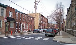
 1500 block of E. Berks Street, a typical residential street in Fishtown, in 2007 in the Bridesburg-Kensington-Richmond planning district | |
 Map of Philadelphia County with Northeast highlighted, which contains the River Wards section (the area labeled here as 'Kensington' is roughly equivalent to the River Wards). Click for larger image. | |
| Country | |
| State | |
| County | |
| City | |
| Area | |
• Total | 8.49 sq mi (22.0 km2) |
| Population (2010) | |
• Total | 88,452 |
| • Density | 10,417/sq mi (4,022/km2) |
| ZIP code | 19124, 19125, 19137 |
The River Wards section of Philadelphia is the innermosot portion of Northeast Philadelphia. 'River Wards' is the commonly used name for an area including Fishtown, Kensington, Port Richmond and Olde Richmond, among other neighborhoods.[1] The area "... was once predominantly industrial. However, most heavy industry has now left."[2] According to an official Philadelphia parks agency, the official designation of "Bridesburg-Kensington-Richmond" by the planning commission is reflected in the way the parks system is set up.[3]
On May 12, 2015, an Amtrak train derailed in Harrowgate.
Demographics
The demographics of Bridesburg-Kensington-Richmond shows that the area has a population 151,862, with 71,591 males, 80,268 females and a median age of 33.[4]
Included neighborhoods
Racial demographics
- Non-Hispanic White: 36,442 (41.2%)
- Hispanic or Latino of any race: 30,958 (35.0%)
- Non-Hispanic Black: 13,002 (14.7%)
- Asian: 5,218 (5.9%)
- Mixed or Other: 2,830 (3.2%)
References
- ^ a b c d e https://www.visitphilly.com/media-center/press-releases/neighborhood-guide-fishtown-river-wards/
- ^ "Bridesburg - Kensington– Richmond". Archived from the original on 2009-01-09.
- ^ "Swimming Pools".
- ^ "Kensington - Richmond, Philadelphia, PA".
- ^ "Factfinder at census.gov". Archived from the original on 2011-12-01. Retrieved 2013-10-14.
- ^ "2010 Census". Medgar Evers College. Archived from the original on 2010-06-11. Retrieved 2010-04-13.
