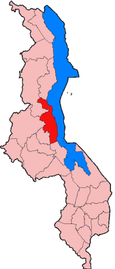
Nkhotakota District
Appearance

Nkhotakota is a district in the Central Region of Malawi. The capital is Nkhotakota. The district covers an area of 4,259 km² and has a population of 395,897.[1] The word Nkhotakota means "zig-zag" in Chichewa. It is located along the shore of Lake Malawi.
Demographics
[edit]At the time of the 2018 Census of Malawi, the distribution of the population of Nkhotakota District by ethnic group was as follows:[2]
- 75.8% Chewa
- 10.4% Tonga
- 3.9% Tumbuka
- 2.1% Lomwe
- 2.3% Ngoni
- 1.9% Yao
- 1.7% Sena
- 0.5% Nyanja
- 0.4% Nkhonde
- 0.4% Mang'anja
- 0.2% Lambya
- 0.1% Sukwa
- 0.2% Others
Government and administrative divisions
[edit]There are five National Assembly constituencies in Nkhotakota:[3]
- Nkhotakota - Central
- Nkhotakota - North
- Nkhotakota - North East
- Nkhotakota - South
- Nkhotakota - South East
References
[edit]- ^ "2018 Population and Housing Census Main Report" (PDF). Malawi National Statistical Office. Retrieved 25 December 2019.
- ^ 2018 Malawi Population and Housing Census Main Report
- ^ Parliament of Malawi - Members of Parliament - Nkhotakota District
13°00′S 34°05′E / 13.000°S 34.083°E
