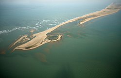
Dhanushkodi
Dhanushkodi | |
|---|---|
Former settlement | |
 Aerial view | |
| Nickname: Ram Setu | |
| Coordinates: 9°09′07″N 79°26′45″E / 9.152011°N 79.445851°E | |
| Country | |
| State | Tamil Nadu |
| District | Ramanathapuram |
| Destroyed | 1964 |
| Elevation | 0 m (0 ft) |
| Time zone | UTC+05:30 (IST) |
| Telephone code | +04567 |
Dhanushkodi is an abandoned town at the south-eastern tip of Pamban Island of the state of Tamil Nadu in India.[1] It is south-east of Pamban and is about 24 kilometres (15 mi) west of Talaimannar in Sri Lanka. The town was destroyed during the 1964 Rameswaram cyclone and remains uninhabited in the aftermath. Today only a few vendors and restaurants can be seen at Dhanushkodi during the day along with the ruins of the long destroyed town.[citation needed]
Geography
Dhanushkodi is on the tip of Pamban island, separated from the mainland by the Palk Strait.
Transport

The National Highway completed the 9.5-km-long road – 5 km from Mukuntharayar Chathiram to Dhanushkodi and 4.5 km from Dhanushkodi to Arichamunai.[2] Until 2016, Dhanushkodi was reachable either on foot along the seashore or in jeeps.[3] In 2016, a road was completed from the village of Mukundarayar Chathiram.[4][5]
A metre gauge railway line connected Mandapam on mainland India to Dhanushkodi.[6] Boat mail express ran from Chennai Egmore to Dhanushkodi till 1964 when the metre-gauge branch line from Pamban to Dhanushkodi was destroyed during the 1964 Dhanushkodi cyclone.[7][8] In 2003, Southern Railway sent a project report to Ministry of Railways for re-laying a 16 kilometres (9.9 mi) railway line to Dhanushkodi from Rameswaram. The planning commission looked into the possibility of a new railway line between Dhanushkodi and Rameswaram in 2010.[9][10]
1964 cyclone
The area around Rameswaram is prone to high-intensity geomorphic activity. A scientific study conducted by the Geological Survey of India indicated that the southern part of Dhanushkodi facing the Gulf of Mannar sank by almost 5 metres (16 ft) in 1948 and 1949, due to vertical tectonic movement of land parallel to the coastline. As a result of this, a patch of land of about 0.5 kilometres (0.31 mi) in width, stretching 7 kilometres (4.3 mi) from north to south, submerged under the sea.[11]
On 17 December 1964, a tropical depression formed at 5°N 93°E in the South Andaman Sea. On 19 December, it intensified into a cyclonic storm. After 21 December 1964, it moved westwards, almost in a straight line, at the rate of 400 to 550 kilometres (250 to 340 mi) per day. On 22 December, it crossed Vavunia in Sri Lanka and made landfall at Dhanushkodi on the night of 22–23 December 1964. Estimated wind velocity was 280 kilometres per hour (170 mph) and tidal waves were 7 metres (23 ft) high.[12]
An estimated 1,800 people died in the cyclonic storm on 22 December including 115 passengers on board the Pamban-Dhanushkodi passenger train.[13][14][15] The entire town was marooned and the Government of Madras declared Dhanushkodi as a ghost town, unfit for living.[16]
In December 2004, around the 40th anniversary of the deadly cyclone, the sea around Dhanushkodi receded about 500 metres (1,600 ft) from the coastline, briefly exposing the submerged part of the town before massive tsunami waves struck the coast.[17][18]
The wreckage of the Rameswaram-Dhanushkodi passenger train, which was hit by the cyclone and tidal waves that struck the area on December 22, lies half submerged here. More than 115 people died in the area-wide calamity 1964.12.31 (UPI Radiophoto)
The locomotive in the picture is B Class 4-6-0 No. 31376 built by North British.[1]
See also
References
- ^ "Did you know? Dhanushkodi is the place where you can see the origin of the Ram Setu!".
- ^ Scott, D. J. Walter (26 July 2017). "Modi to inaugurate Dhanushkodi road". The Hindu. Ramanathapuram: Kasturi & Sons. Retrieved 1 November 2021.
- ^ "Dhanushkodi still attracts tourists". The Hindu. 28 June 2010. Archived from the original on 3 July 2010.
- ^ D.J. Walter Scot (4 February 2016). "Road to Dhanushkodi may be opened by month-end". The Hindu.
- ^ "Four-lane road planned for Dhanushkodi". The Hindu.
- ^ Jethwa, Raja Pawan (2007). "Section II: Mileage wise available Details of Railway lines laid". Shree Kutch Gurjar Kshatriya Samaj: A brief History & Glory of our fore-fathers. pp. 63–70.
- ^ Saqaf, Syed Muthahar (11 June 2010). "'Boat Mail' to run on main line from August 1". The Hindu.
- ^ Jaishankar, C (17 July 2006). "Their sentiment to metre gauge train is unfathomable". The Hindu. Archived from the original on 27 October 2007.
- ^ C. Jaishankar (26 February 2010). "Railway budget may put Dhanushkodi back on track". The Hindu. Archived from the original on 2 March 2010.
- ^ "Poll-bound TN, Kerala will get more trains". The Asian Age. 26 February 2011.
- ^ G. G. Vaz; M. Hariprasad; B. R. Rao; V. Subba Rao (10 March 2007). "Subsidence of southern part of erstwhile Dhanushkodi township, Tamil Nadu". Current Science. 92: 671–672.
- ^ Shashi M Kulshreshta; Madan G Gupta (June 1966). "Satellite Study of the Rameswaram Cyclonic Storm of 20–23 December 1964". Journal of Applied Meteorology and Climatology. 5 (3): 373–376. doi:10.1175/1520-0450(1966)005<0373:ssotrc>2.0.co;2. ISSN 0021-8952.
- ^ "India Train, 150 Aboard, Swept Away By Big Wave". St. Petersburg Times. UPI. 26 December 1964. p. 3A.
- ^ "1,800 Asians Feared Dead After Cyclone and Tidal Wave". Reading Eagle. UPI. 28 December 1964. p. 4.
- ^ "Ships, Planes Search for Survivors". The Age. A.A.P.-Reuters. 28 December 1964. p. 4.
- ^ "Eye-witness account of the cyclone". The Hindu.
- ^ "Submerged temple tower visible in Dhanushkodi". Zee news.
- ^ G. G. Vaz; M. Hariprasad; B. R. Rao & V. Subba Rao (March 2007). "Subsidence of southern part of erstwhile Dhanushkodi township, Tamil Nadu – evidences from bathymetry, side scan and underwater videography" (PDF). Current Science (PDF). 92 (5): 671–675.


