Kausar Nag
Appearance
| Kausar Nag | |
|---|---|
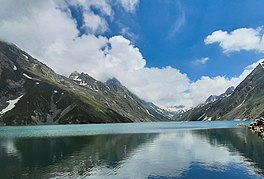
 Kausar Nag Lake in August | |
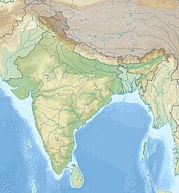
| Location | Kulgam, Kashmir valley, India |
| Coordinates | 33°30′44″N 74°46′08″E / 33.5123°N 74.7688°E |
| Type | Oligotrophic lake |
| Primary inflows | Melting of snow |
| Primary outflows | A tributary of Aharbal waterfall |
| Max. length | 3 kilometres (1.9 mi) |
| Max. width | 0.9 kilometres (0.56 mi) |
| Surface elevation | 3,962.4 metres (13,000 ft) |
| Frozen | November to July |

Kausar Nag or Kausarnag (sometimes alternatively spelled as Konsarnag), is a high-altitude oligotrophic lake located at an elevation of 3,962.4 metres (13,000 ft) above sea level.[1] Kausar Nag is located in the Pir Panjal mountain range in Kulgam district of Jammu and Kashmir, India. The lake is roughly 3 km (2 mi) long and .75 km (0 mi) at the widest point.[2]
Legends
It is believed that Manu's boat that carried the Vedas and the Saptarishi was stuck near this Lake after the Great flood.[3]
See also
References
- ^ G. M. D. Sufi (2006). Kashīr, being a history of Kashmīr from the earliest times to our own, Volume 1. University of Michigan. p. 44.
- ^ "VAM :: Vertical Amble Mountaineering: Kausar Nag Trek Information". Verticalamble.in. Retrieved 3 August 2014.
- ^ https://www.people.fas.harvard.edu/~witzel/KashmiriBrahmins.pdf [bare URL PDF]


