Girgaon
Appearance
Girgaon | |
|---|---|
Neighbourhood | |
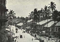
 Girgaon back road, c. 1905 | |
| Coordinates: 18°57′11″N 72°48′47″E / 18.953°N 72.813°E | |
| Country | India |
| State | Maharashtra |
| District | Mumbai City |
| City | Mumbai |
| Government | |
| • Type | Municipal Corporation |
| • Body | Brihanmumbai Municipal Corporation (MCGM) |
| Elevation | 12 m (39 ft) |
| Demonym | Girgaonkar |
| Languages | |
| • Official | Marathi |
| Time zone | UTC+5:30 (IST) |
| PIN | 400004 |
Girgaon, or Girgaum, is an area in southern Mumbai in Maharashtra, India. It is near the coast.[1] A section of Marine Drive is located here.[2]
See also
References
- ^ Karmakar, Kalyan (2016). The Travelling Belly : Eating Through India's By-Lanes. Gurgaon. ISBN 978-93-5009-911-7. OCLC 968895956.
{{cite book}}: CS1 maint: location missing publisher (link) - ^ Census of India, 1981: Maharashtra. Series 12. Manager of Publications. 1986. p. 36.
External links
Wikimedia Commons has media related to Girgaum.

