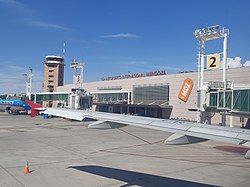
Governor Francisco Gabrielli International Airport
Appearance
Governor Francisco Gabrielli International Airport Aeropuerto Internacional de Mendoza "Francisco Gabrielli" – El Plumerillo | |||||||||||
|---|---|---|---|---|---|---|---|---|---|---|---|
 | |||||||||||
| Summary | |||||||||||
| Airport type | Public / Military | ||||||||||
| Operator | Aeropuertos Argentina 2000 | ||||||||||
| Serves | Mendoza, Argentina | ||||||||||
| Elevation AMSL | 2,310 ft / 704 m | ||||||||||
| Coordinates | 32°49′54″S 068°47′34″W / 32.83167°S 68.79278°W | ||||||||||
| Map | |||||||||||
 | |||||||||||
| Runways | |||||||||||
| |||||||||||
| Statistics (2017) | |||||||||||
| |||||||||||
Governor Francisco Gabrielli International Airport (Template:Lang-es) (IATA: MDZ, ICAO: SAME), better known as El Plumerillo International Airport, is located 8 kilometres (5.0 mi) northeast of the centre of Mendoza, capital of the Mendoza Province of Argentina. It is operated by Aeropuertos Argentina 2000[2][3]
The 4th Air Brigade (El Plumerillo Military Air Base) is located on the southern section of the airport.[6]
Airlines and destinations
Statistics
| Passengers | Change from previous year | Aircraft operations | Change from previous year | Cargo (metric tons) |
Change from previous year | |
|---|---|---|---|---|---|---|
| 2005 | 652,504 | 14,938 | 2,645 | |||
| 2006 | 655,318 | 12,586 | 3,054 | |||
| 2007 | 689,963 | 10,625 | 3,364 | |||
| 2008 | 780,464 | 12,017 | 3,436 | |||
| 2009 | 858,984 | 12,354 | 2,759 | |||
| 2010 | 976,889 | 13,688 | 5,533 | |||
| Source: Airports Council International. World Airport Traffic Statistics (Years 2005-2010) | ||||||
Accidents and incidents
- 20 January 1944: A LanChile Lodestar 18–50, registration CC-CLC-0072, was due to operate a Mendoza–San Juan cargo service when it crashed on takeoff, killing all 12 occupants aboard.[8]
See also
References
- ^ "Archived copy" (PDF). Archived from the original (PDF) on 13 March 2018. Retrieved 12 March 2018.
{{cite web}}: CS1 maint: archived copy as title (link) - ^ a b "SAME – MENDOZA / El Plumerillo" (PDF). Archived from the original (PDF) on 31 May 2011. at AIP Argentina (in Spanish)
- ^ a b Aeropuerto Internacional de Mendoza "Francisco Gabrielli" – El Plumerillo Archived 7 February 2012 at the Wayback Machine at Organismo Regulador del Sistema Nacional de Aeropuertos (ORSNA) (in Spanish)
- ^ "Airport information for Governor Francisco Gabrielli International Airport". World Aero Data. Archived from the original on 5 March 2019.
{{cite web}}: CS1 maint: unfit URL (link) Data current as of October 2006. - ^ "Aeropuerto Mendoza". Google Maps. Retrieved 19 May 2019.
- ^ "4th Air Brigade". X Air Forces. Retrieved 19 May 2019.
- ^ "Aerolíneas Argentinas To Connect Mendoza & Rio De Janeiro". Simple Flying. 25 September 2022.
- ^ Accident description for CC-CLC-0072 at the Aviation Safety Network. Retrieved on 25 June 2012.
External links
- Mendoza Airport Aeropuertos Argentina 2000
- Airport information for El Plumerillo International Airport at Great Circle Mapper.
- Current weather for SAME at NOAA/NWS
- Accident history for Mendoza-El Plumerillo Airport at Aviation Safety Network

