Jump to content

Khorramabad County

Coordinates: 33°30′N 48°20′E / 33.500°N 48.333°E / 33.500; 48.333
From Wikipedia, the free encyclopedia

This is an old revision of this page, as edited by Brightkingdom (talk | contribs) at 20:39, 11 December 2022 (Cleaned up infobox, body copy, end matter; uncollapsed table, removed 2016 table; added 2016 census figures). The present address (URL) is a permanent link to this revision, which may differ significantly from the current revision.

Khorramabad County
شهرستان خرم‌آباد
County
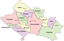
Location of Khorramabad County in Lorestan province
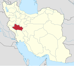
Location of Lorestan province in Iran
Coordinates: 33°30′N 48°20′E / 33.500°N 48.333°E / 33.500; 48.333
CountryIran
ProvinceLorestan
CapitalKhorramabad
DistrictsCentral, Bayravand, Papi, Zagheh
Population
 (2016)
 • Total
506,471
Time zoneUTC+3:30 (IRST)
 • Summer (DST)UTC+4:30 (IRDT)
Khorramabad County can be found at GEOnet Names Server, at this link, by opening the Advanced Search box, entering "9207199" in the "Unique Feature Id" form, and clicking on "Search Database".

Khorramabad County (Template:Lang-fa) is located in Lorestan province, Iran. The capital of the county is Khorramabad. At the 2006 census, the county's population (including those portions of the county later split off to form Dowreh County) was 509,251, in 113,886 households.[1] At the 2016 census, the county's population was 506,471, in 144,958 households.[2]

Administrative divisions

Khorramabad County (2006)[1]
Administrative Divisions Pop.
Central District 417,556
Azna Rural District 6,214
Dehpir Rural District 7,479
Dehpir-e Shomali Rural District 6,332
Kakasharaf Rural District 4,091
Koregah-e Gharbi Rural District 45,409
Koregah-e Sharqi Rural District 11,294
Robat Rural District 8,193
Khorramabad (city) 328,544
Bayravand District 11,378
Beyranvand-e Jonubi Rural District 6,309
Beyranvand-e Shomali Rural District 3,525
Bayranshahr (city) 1,544
Dowreh-e Chegeni District1 31,117
Dowreh Rural District 9,208
Kashkan Rural District 10,294
Teshkan Rural District 10,303
Sarab-e Dowreh (city) 1,312
Papi District 16,898
Chamsangar Rural District 2,520
Gerit Rural District 2,145
Keshvar Rural District 1,873
Sepiddasht Rural District 5,117
Tang-e Haft Rural District 2,046
Sepiddasht (city) 3,197
Veysian District1 13,029
Shurab Rural District 5,081
Veysian Rural District 6,131
Mahmudvand (city) 1,817
Zagheh District 19,273
Qaedrahmat Rural District 7,381
Razan Rural District 3,102
Zagheh Rural District 5,951
Zagheh (city) 2,839
Total 509,251
1Became a part of Dowreh County

References

  1. ^ a b "Census of the Islamic Republic of Iran, 1385 (2006)" (Excel). Statistical Center of Iran. Archived from the original on 2011-09-20. Retrieved 7 November 2022
  2. ^ "Census 2016: Population and Households of the Country by Province and Sub-province (Shahrestan)" (Excel). Iran Data Portal. The Statistical Center of Iran. Retrieved 11 December 2022.