Jump to content

Toms (islet)

Coordinates: 18°5′18.35″S 163°9′37.31″W / 18.0884306°S 163.1603639°W / -18.0884306; -163.1603639
From Wikipedia, the free encyclopedia

This is the current revision of this page, as edited by Schwede66 (talk | contribs) at 04:56, 13 February 2023 (script-assisted date audit and style fixes per MOS:NUM). The present address (URL) is a permanent link to this version.

(diff) ← Previous revision | Latest revision (diff) | Newer revision → (diff)

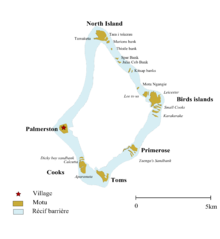
Map of Palmerston

Toms is an islet in Palmerston Island in the Cook Islands. It is at the southern tip of the atoll, between Primrose and Cooks. The island is named after someone from Palmerston's history.[1]

References

[edit]
  1. ^ Rachel Hendery (2016). "Populating the landscape with absent friends: the use of personal names in Palmerston Island toponyms" (PDF). Island Studies Journal. 11 (2): 365. Retrieved 15 September 2020.

18°5′18.35″S 163°9′37.31″W / 18.0884306°S 163.1603639°W / -18.0884306; -163.1603639