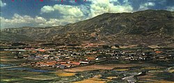
Zhaojue County
Appearance
Zhaojue County
昭觉县 · ꏪꐦꑤ | |
|---|---|
 Zhaojue County in 1964 | |
 Location of Zhaojue County (red) within Liangshan Prefecture (yellow) and Sichuan | |
| Coordinates: 28°00′50″N 102°50′35″E / 28.014°N 102.843°E | |
| Country | People's Republic of China |
| Province | Sichuan |
| Autonomous prefecture | Liangshan |
| Area | |
• Total | 2,699 km2 (1,042 sq mi) |
| Highest elevation | 3,878 m (12,723 ft) |
| Lowest elevation | 520 m (1,710 ft) |
| Time zone | UTC+8 (China Standard) |
Zhaojue County (Template:Lang-ii) is a county in the south of Sichuan Province, China. It is under the administration of the Liangshan Yi Autonomous Prefecture. It has a population of 322,600 as of 2021, including 98.53% Yi. The name Zhaojue is a transliteration in Chinese of the Yi words for 'mountain eagle's plain', or 'sloped plain'.[1][2]
Atulie'er Village
The remote Atulie'er village[3] (Atulie'ercun, 阿土列尔村), is located in the Zhi'ermo Township (支尔莫乡)[4] of Zhaojue County. The village was the focus of a Chinese news video and photojournalism that became international news in May, 2016.[5] Villages such as Atuli'er are often dubbed cliff villages due to their height and remoteness.
Climate
| Climate data for Zhaojue (1981−2010 normals) | |||||||||||||
|---|---|---|---|---|---|---|---|---|---|---|---|---|---|
| Month | Jan | Feb | Mar | Apr | May | Jun | Jul | Aug | Sep | Oct | Nov | Dec | Year |
| Record high °C (°F) | 23.9 (75.0) |
25.6 (78.1) |
30.8 (87.4) |
31.0 (87.8) |
33.0 (91.4) |
33.1 (91.6) |
31.3 (88.3) |
31.9 (89.4) |
31.6 (88.9) |
28.4 (83.1) |
24.6 (76.3) |
21.5 (70.7) |
33.1 (91.6) |
| Mean daily maximum °C (°F) | 8.8 (47.8) |
11.6 (52.9) |
16.2 (61.2) |
19.8 (67.6) |
21.6 (70.9) |
22.3 (72.1) |
24.4 (75.9) |
24.5 (76.1) |
21.0 (69.8) |
16.4 (61.5) |
13.7 (56.7) |
10.0 (50.0) |
17.5 (63.5) |
| Daily mean °C (°F) | 1.6 (34.9) |
4.0 (39.2) |
8.0 (46.4) |
12.1 (53.8) |
15.1 (59.2) |
17.1 (62.8) |
19.0 (66.2) |
18.6 (65.5) |
15.4 (59.7) |
11.3 (52.3) |
7.4 (45.3) |
3.1 (37.6) |
11.1 (51.9) |
| Mean daily minimum °C (°F) | −2.2 (28.0) |
−0.4 (31.3) |
2.8 (37.0) |
6.9 (44.4) |
10.7 (51.3) |
13.7 (56.7) |
15.4 (59.7) |
14.8 (58.6) |
12.1 (53.8) |
8.4 (47.1) |
3.9 (39.0) |
−0.7 (30.7) |
7.1 (44.8) |
| Record low °C (°F) | −11.3 (11.7) |
−10.2 (13.6) |
−7.4 (18.7) |
−2.3 (27.9) |
−0.1 (31.8) |
7.8 (46.0) |
8.6 (47.5) |
7.4 (45.3) |
3.2 (37.8) |
−0.4 (31.3) |
−5.6 (21.9) |
−17.0 (1.4) |
−17.0 (1.4) |
| Average precipitation mm (inches) | 9.4 (0.37) |
12.9 (0.51) |
26.5 (1.04) |
55.0 (2.17) |
117.1 (4.61) |
203.6 (8.02) |
205.1 (8.07) |
158.4 (6.24) |
135.0 (5.31) |
76.0 (2.99) |
25.2 (0.99) |
8.8 (0.35) |
1,033 (40.67) |
| Average precipitation days (≥ 0.1 mm) | 6.2 | 6.8 | 9.7 | 12.5 | 15.7 | 20.8 | 18.8 | 17.0 | 17.1 | 17.0 | 7.8 | 6.7 | 156.1 |
| Average snowy days | 7.0 | 6.2 | 3.5 | 0.3 | 0 | 0 | 0 | 0 | 0 | 0 | 1.8 | 4.9 | 23.7 |
| Average relative humidity (%) | 75 | 69 | 66 | 69 | 74 | 81 | 81 | 81 | 83 | 84 | 80 | 78 | 77 |
| Mean monthly sunshine hours | 150.0 | 162.7 | 205.7 | 206.0 | 184.8 | 126.2 | 151.3 | 168.5 | 125.8 | 112.0 | 150.2 | 140.4 | 1,883.6 |
| Percent possible sunshine | 46 | 51 | 55 | 53 | 44 | 30 | 36 | 42 | 35 | 32 | 47 | 44 | 43 |
| Source: China Meteorological Administration (precipitation days, snow days, sunshine 1991–2020)[6][7] | |||||||||||||
See also
References
- ^ "昭觉概况". www.zhaojue.gov.cn. Retrieved 2021-12-09.
- ^ 中华人民共和国地名大词典 (in Chinese). 商务印书馆. 1998. ISBN 978-7-100-01836-4.
- ^ Google Maps Village Location
- ^ Chinese Wikipedia site for Zhi'ermo Township Branch
- ^ "China to replace treacherous 2,625-foot ladder to school with stairs." Fox News. May 27, 2016. Retrieved on May 28, 2016.
- ^ 中国气象数据网 – WeatherBk Data (in Simplified Chinese). China Meteorological Administration. Retrieved 14 April 2023.
- ^ 中国气象数据网 (in Simplified Chinese). China Meteorological Administration. Retrieved 14 April 2023.
