Mamasani County
Mamasani County
شهرستان ممسنی | |
|---|---|
County | |
 Mamasani's Tower, by Eugène Flandin | |
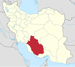
 Location of Mamasani County in Fars province | |
 Location of Fars province in Iran | |
| Coordinates: 30°06′N 51°20′E / 30.100°N 51.333°E | |
| Country | Iran |
| Province | Fars |
| Capital | Nurabad |
| Districts | Central, Doshman Ziari, Mahvarmilani |
| Population (2016) | |
• Total | 117,527 |
| Time zone | UTC+3:30 (IRST) |
| • Summer (DST) | UTC+4:30 (IRDT) |
| Website | https://radiomamasani.ir |
| Mamasani County can be found at GEOnet Names Server, at this link, by opening the Advanced Search box, entering "-3073848" in the "Unique Feature Id" form, and clicking on "Search Database". | |
Mamasani County (Template:Lang-fa) is in Fars province, Iran. The capital of the county is the city of Nurabad, 180 kilometers from Shiraz. At the 2006 census, the county's population was 162,694 in 35,145 households.[1] The following census in 2011 counted 116,386 people in 30,928 households, by which time Rostam District had been separated from the county to form Rostam County.[2] At the 2016 census, the county's population was 117,527 in 35,060 households.[3]
The Mamasani (also Mohammad-Hassani) tribe also resides in this county and speaks the Mamasani dialect of the Luri language.
Administrative divisions
The population history and structural changes of Mamasani County's administrative divisions over three consecutive censuses are shown in the following table. The latest census shows three districts, nine rural districts, and three cities.[3]
| Administrative Divisions | 2006[1] | 2011[2] | 2016[3] |
|---|---|---|---|
| Central District | 97,206 | 98,973 | 98,816 |
| Bakesh-e Do Rural District | 6,625 | 5,483 | 5,271 |
| Bakesh-e Yek Rural District | 17,107 | 11,484 | 11,006 |
| Fahlian Rural District | 5,163 | 4,920 | 4,495 |
| Javid-e Mahuri Rural District | 9,122 | 8,425 | 7,729 |
| Jowzar Rural District | 7,521 | 6,830 | 7,037 |
| Khumeh Zar (city) | 6,095 | 6,220 | |
| Nurabad (city) | 51,668 | 55,736 | 57,058 |
| Doshman Ziari District | 10,196 | 9,463 | 9,326 |
| Doshman Ziari Rural District | 4,944 | 4,840 | 4,542 |
| Mashayekh Rural District | 5,252 | 4,623 | 4,784 |
| Mahvarmilani District | 9,915 | 7,311 | 5,297 |
| Mahur Rural District | 5,614 | 4,892 | 2,251 |
| Mishan Rural District | 4,301 | 2,419 | 1,667 |
| Baba Monir (city) | 1,379 | ||
| Rostam District1 | 45,377 | ||
| Poshtkuh-e Rostam Rural District | 9,106 | ||
| Rostam-e Do Rural District | 6,864 | ||
| Rostam-e Seh Rural District | 9,525 | ||
| Rostam-e Yek Rural District | 14,517 | ||
| Masiri (city) | 5,365 | ||
| Total | 162,694 | 116,386 | 117,527 |
| 1 Became a part of Rostam County | |||
References
- ^ a b "Census of the Islamic Republic of Iran, 1385 (2006)". AMAR (in Persian). The Statistical Center of Iran. p. 07. Archived from the original (Excel) on 20 September 2011. Retrieved 25 September 2022.
- ^ a b "Census of the Islamic Republic of Iran, 1390 (2011)" (Excel). Iran Data Portal (in Persian). The Statistical Center of Iran. p. 07. Retrieved 19 December 2022.
- ^ a b c "Census of the Islamic Republic of Iran, 1395 (2016)". AMAR (in Persian). The Statistical Center of Iran. p. 07. Archived from the original (Excel) on 6 April 2022. Retrieved 19 December 2022.
External links
- A Mamasani folk song sung by Shusha Guppy in the 1970s: You Must Come to Me

