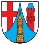
Trier-Land
Appearance
| Arms | Map |
|---|---|

|

|
| Country: | Germany |
| State: | Rhineland-Palatinate |
| District: | Trier-Saarburg |
| Verbandsgemeinde: | Trier-Land |
Trier-Land is a Verbandsgemeinde ("collective municipality") in the Trier-Saarburg district, in Rhineland-Palatinate, Germany. It is situated on the border with Luxembourg, north and west of Trier. The seat of the municipality is in Trier, itself not part of the municipality.
The Verbandsgemeinde Trier-Land consists of the following Ortsgemeinden ("local municipalities"):
- Aach
- Franzenheim
- Hockweiler
- Igel
- Kordel
- Langsur
- Newel
- Ralingen
- Trierweiler
- Welschbillig
- Zemmer
The village Igel is known for the Column of Igel, a UNESCO World Heritage Site. The Column of Igel is a 23 m high Roman decorated tomb.

