Impilahti
Impilahti
Импила́хти | |
|---|---|
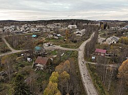
 An aerial view of Impilahti in 2020. | |
| Coordinates: 61°40′14.88″N 31°09′16.47″E / 61.6708000°N 31.1545750°E | |
| Country | Russia |
| Federal subject | Republic of Karelia |
| Charter | 1638[1] |
| • Municipal district | Pitkyarantsky Municipal District |
| Time zone | UTC+3 (UTC+03:00 |
| Postal code(s)[3] | |
| OKTMO ID | 86633405101 |
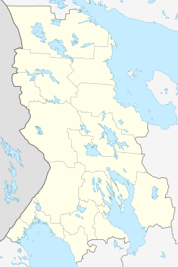
Impilahti (Template:Lang-ru; Template:Lang-krl; Template:Lang-sv) is a small town in the Republic of Karelia, Russia, located at the northern tip of Lake Ladoga near the Finnish border, about 200 kilometres (120 mi) west of Petrozavodsk, the capital city of the Republic of Karelia. The nearest town is Sortavala, which is located about 40 kilometres (25 mi) west of Sortavala. Before the World War II, the area belonged to Finland, after which it became part of the Soviet Union.
In 2012 the population of Impilahti was about one thousand.[4] According to the 2010 census, 74% of the population are Russian, 9% Belarusian, 7% Karelian, 3% Ukrainian and 2% Finnish.[5]
Geography
In addition to Lake Ladoga, there are other smaller lakes in Impilahti and several rivers flow in the area. Most of the land area is forest. Minerals include granite, gneiss, amphibolite, slate, sand and gravel.[4]
Sights and tourism

To the east of the village of Leppäsilta is a Stone Age settlement. Impilahti's center has the status of a historical settlement. Building monuments include the preserved Impilahti parsonage, school, bank and hotel from the Finnish era, as well as two residential buildings. Impilahti has the graves of Soviet and Finnish soldiers who fell in the Winter and Continuation War, as well as Soviet prisoners of war. The municipality also has several holiday villages and hunting lodges.[4]
Transportation
The A130 highway between Olonets and Sortavala passes through Impilahti. There are bus connections from the center to Pitkyaranta and Sortavala.[4]
Industry
In Impilahti, there are two fish farms, a cattle farm, a sewing factory and a building materials industry.[4] From 2003 to 2022, a sawmill owned by Stora Enso operated in Impilahti.[6][7]
Notable people
- Aleksanteri Ahola-Valo (1900–1997), artist and architect
- Aleksander Auvinen (1857–1918), Lutheran priest and politician
- Arvid Genetz (1848–1915), politician, poet and linguist
- Emil Genetz (1852–1930), composer
- William Kanerva (1902–1956), footballer
- Ensio Koivunen (1930–2003), serial killer
- Mauno Luukkonen (born 1934), biathlete
- Mikko Piitulainen (1878–1935), farmer, attorney and politician
- Pentti Saarikoski (1937–1983), poet
- Jaakko Seise (1876–1935), businessman, a member of the Finnish White Guard and a Nazi politician
- Elias Simojoki (1899–1940), clergyman
- Basilius Suosaari (born Vasili Tichanoff; 1861–1939), Finnish-Australian politician and farmer
- Alli Vaittinen-Kuikka (1918–2006), nurse, midwife and politician
See also
References
Notes
- ^ "Impilahden kirkot ja kirkolliset esineet" (PDF). Impilahtelainen (in Finnish). 2012. Retrieved 19 June 2023.
- ^ "Об исчислении времени". Официальный интернет-портал правовой информации (in Russian). 3 June 2011. Retrieved 19 January 2019.
- ^ Почта России. Информационно-вычислительный центр ОАСУ РПО. (Russian Post). Поиск объектов почтовой связи (Postal Objects Search) (in Russian)
- ^ a b c d e "Generalnyi plan Impilahtinskogo selskogo poselenija Pitkjarantskogo munitsipalnogo raiona Respubliki Karelija: Materialy po obosnovaniju v tekstovoi forme" (PDF). Gradeco.ru (in Russian). Retrieved 19 June 2023.
- ^ "SuperWEB2 – Вход". std.gmcrosstata.ru (in Russian). Retrieved 19 June 2023.
- ^ "Stora Enso: Impilahti Sawmill". Stora Enso. Retrieved 19 June 2023.
- ^ Okkonen, Katja (25 April 2022). "Stora Enso myy sahansa ja puunhankintansa Venäjällä". Ilta-Sanomat (in Finnish). Retrieved 19 June 2023.
External links
![]() Media related to Impilahti at Wikimedia Commons
Media related to Impilahti at Wikimedia Commons
- Poselok Impilahti – Kareliya.ru (in Russian)
- Impilahti – Luovutettu Karjala (in Finnish)


