Wuda District
Appearance
Wuda
Ud 乌达区 • ᠤᠳᠠ ᠲᠣᠭᠤᠷᠢᠭ | |
|---|---|
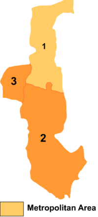
 Wuda is the division labeled '3' on this map of Wuhai City | |
| Coordinates (Wuda District government): 39°30′20″N 106°43′34″E / 39.5056°N 106.7260°E | |
| Country | China |
| Prefecture-level city | Wuhai |
| Area | |
• Total | 195.2 km2 (75.4 sq mi) |
| Population (2020)[1] | |
• Total | 122,696 |
| Time zone | UTC+8 (China Standard) |
Wuda District or Ud District (Mongolian: ᠤᠳᠠ ᠲᠣᠭᠤᠷᠢᠭ Уд тойрог Uda toɣoriɣ; simplified Chinese: 乌达区; traditional Chinese: 烏達區; pinyin: Wūdá Qū) is a district of the city of Wuhai, Inner Mongolia, China, located on the west (left) bank of the Yellow River.
Administrative divisions
Wuda District is made up of 7 subdistricts and 1 town.
| Name | Simplified Chinese | Hanyu Pinyin | Mongolian (Hudum Script) | Mongolian (Cyrillic) | Administrative division code |
|---|---|---|---|---|---|
| Subdistricts | |||||
| Sandaokan Subdistrict | 三道坎街道 | Sāndàokǎn Jiēdào | ᠰᠠᠨ ᠳ᠋ᠣᠤ ᠺᠠᠨ ᠵᠡᠭᠡᠯᠢ ᠭᠤᠳᠤᠮᠵᠢ | 150304002 | |
| Wuhushan Subdistrict | 五虎山街道 | Wǔhǔshān Jiēdào | ᠡᠦ ᠬᠤ ᠱᠠᠨ ᠵᠡᠭᠡᠯᠢ ᠭᠤᠳᠤᠮᠵᠢ | 150304003 | |
| Xinda Subdistrict | 新达街道 | Xīndá Jiēdào | ᠰᠢᠨ ᠳ᠋ᠠ ᠵᠡᠭᠡᠯᠢ ᠭᠤᠳᠤᠮᠵᠢ | 150304008 | |
| Bayan Sain Subdistrict | 巴音赛街道 | Bāyīnsài Jiēdào | ᠪᠠᠶᠠᠨᠰᠠᠢᠨ ᠵᠡᠭᠡᠯᠢ ᠭᠤᠳᠤᠮᠵᠢ | 150304008 | |
| Liangjiagou Subdistrict | 梁家沟街道 | Liángjiāgōu Jiēdào | ᠯᠢᠶᠠᠩ ᠵᠢᠶᠠ ᠭᠧᠦ ᠵᠡᠭᠡᠯᠢ ᠭᠤᠳᠤᠮᠵᠢ | 150304010 | |
| Suhait Subdistrict | 苏海图街道 | Sūhǎitú Jiēdào | ᠰᠤᠬᠠᠢᠲᠤ ᠵᠡᠭᠡᠯᠢ ᠭᠤᠳᠤᠮᠵᠢ | 150304011 | |
| Town | |||||
| Ulan Nur Town | 乌兰淖尔镇 | Wūlánnào'ěr Zhèn | ᠤᠯᠠᠭᠠᠨ ᠨᠠᠭᠤᠷ ᠪᠠᠯᠭᠠᠰᠤ | 150203100 | |
Other:
- Uda Economic Development Zone (乌达经济开发区)
References
- www.xzqh.org (in Chinese)
