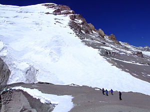
Polish Glacier
Appearance
This article needs additional citations for verification. (March 2007) |

The Polish Glacier[1] (Spanish Glaciar de los Polacos) is one of the glacial fields of Cerro Aconcagua, the highest peak in the Andes and the Americas. It was named after the Polish expedition of 1934.[2] Led by Konstanty Jodko-Narkiewicz, the team developed an alternative route to the peak through the glacier, which was named the Polish Route.[3][4]
See also
References
- ^ http://www.aconcagua.pl Polish website about Aconcagua Polish Glacier
- ^ J. Neate (1994). Mountaineering in the Andes, p187. RGS 1994, ISBN 0-907649-64-5
- ^ Marek, Aneta (2016). "Andy jako rejon eksploracji górskiej Polaków do 1989 r." (PDF). Słupskie Prace Geograficzne (in Polish). 13: 83–104. Archived from the original (PDF) on 16 June 2023.
- ^ "Centro Cultural Argentino de Montaña". Centro Cultural Argentino de Montaña. Retrieved 2023-08-23.
32°39′20″S 70°00′57″W / 32.65556°S 70.01583°W
