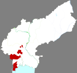
Taihe District
Appearance
Taihe
太和区 | |
|---|---|
 Location in Jinzhou | |
| Coordinates: 41°06′34″N 121°06′14″E / 41.10944°N 121.10389°E | |
| Country | China |
| Province | Liaoning |
| Prefecture-level city | Jinzhou |
| District seat | Taihe Subdistrict |
| Area | |
• Total | 727.68 km2 (280.96 sq mi) |
| Population (2020 census)[1] | |
• Total | 175,098 |
| • Density | 240/km2 (620/sq mi) |
| Time zone | UTC+8 (China Standard) |
| Website | www |
Taihe District (simplified Chinese: 太和区; traditional Chinese: 太和區; pinyin: Tàihé Qū) is a district of the city of Jinzhou, Liaoning, China.
Administrative divisions
[edit]There are 10 subdistricts within the district:
Taihe Subdistrict (太和街道), Daxue Subdistrict (大薛街道), Xinmin Subdistrict (新民街道), Yingpan Subdistrict (营盘街道), Nü'erhe Subdistrict (女儿河街道), Tianqiao Subdistrict (天桥街道), Xingshan Subdistrict (杏山街道), Niangnianggong Subdistrict (娘娘宫街道), Lingnan Subdistrict (凌南街道), Songshan Subdistrict (松山街道).
References
[edit]- ^ "锦州市第七次全国人口普查公报" (in Chinese). Jinzhou Municipal Bureau of Statistics. 2021-06-08.
