Asterius Chapel
| Asterius Chapel | |
|---|---|
 | |
| Religion | |
| Affiliation | Christianism |
| Location | |
| Location | Carthage |
| Country | |
| Geographic coordinates | 36°51′16″N 10°19′57″E / 36.85444°N 10.33250°E |
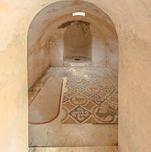
The Asterius chapel is a small underground Christian building dating from the 5th - 7th centuries, now located within the archaeological park of the Baths of Antoninus in the archaeological site of Carthage, Tunisia.
The building - whose function is unknown, although specialists believe it must have had both a liturgical and funerary function - was previously located on the Sayda plateau, formerly known as the "hill of sainte-Monique". The monument was located at the heart of an area that yielded both a late necropolis and cult buildings. It bears witness to the pivotal period between the Vandal kingdom and the Byzantine reconquest of present-day Tunisia.
During excavations in the 1950s, it was decided to move it to the archaeological park, given its state of preservation, so that the mosaic decoration would not be lost as a result of urban development in the area.
Location

The Asterius chapel is located within the archaeological park of Antonin's baths, but comes from an excavation in the Lyceum district of Carthage, northeast of the city,[F 1] on the hill of Sainte-Monique Sayda.[F 2][G 1]
History
Ancient history
History of the ancient city area

Urbanization of the area was "late but regular".[G 2]
The area in which the chapel was found is located on the outskirts of the ancient city, like many Christian buildings. The chapel was discovered in a Byzantine necropolis,[G 3] which may have included a church.[F 3]
The burials in the necropolis were pits covered with flagstones.[H 1] The necropolis was surrounded by an enclosure wall, part of which has been identified.[G 3] Several tombs were excavated, including a painted and stuccoed vault and another with a marble sarcophagus containing a lead coffin.[G 4] Another burial chapel, known as the Chapel of Redemptus, measured 4 m by 6.50 m and was sparsely decorated. The sarcophagus bears the name of the chapel's owner.[G 4]
Proximity to a religious complex

Near the chapel was a cult complex, four rooms of which were excavated, including an underground chamber. The complex was dated to the second half of the 5th century on the basis of coins. A baptistery was present, and one of the rooms featured paintings of saints. Christian graffiti were also found.[G 5]
The space was later refurbished with a more sumptuous décor, featuring floor mosaics and stucco or paintings on the walls, and sometimes marble.[G 6] Above-ground rooms dating back to the first century.[G 7]
The baptistery, fed by a well, is "the most remarkable part of the complex":[G 7] four-lobed in shape, with access via steps on the north-west side. The cells were mosaic-covered, and the bottom of the vat was lined with marble.[G 7] A ciborium and baldachin covered the baptistery. A chancel isolated the area from the rest of the room. The baptistery area featured painted figures with halos, one of whom has been identified as Saturus, one of Perpetua and Felicity's companions.[G 8] The Basilica Majorum was dedicated to these martyrs, and the same may have been true of this building.[G 9]
One dwelling in the area, the vicus castrorum, not far from the Kobba Bent el Rey, yielded the mosaic known as the Four Evangelists, while another yielded the mosaic known as the Lady of Carthage.[G 10]
History of the building
The building has the same orientation as the town's urban grid.[C 1] It may have reused a cistern, and the vaulting was built before the internal fittings. The apse was added later.[C 2] The building had two periods in its history[H 1] and was in use for a long time.[E 1]
The name Asterius[1] appears on a reused inscription on a step.[G 4] Asterius was not the name of the deceased who occupied the tomb.[H 1] A skull was found under the mosaic pavement.[E 1] A tomb was built after this mosaic. According to the paleographic study of the reused inscriptions, the building was not built before the 5th century.[E 2]
During excavations, archaeologists found three Maurice Tiberius coins[C 2] under the mosaic,[F 4][H 1] dating from the building's second state.[C 2] The burial site of Asterius, violated[F 3] at an undetermined time, yielded a skull.[E 3] According to Liliane Ennabli, the building is dated 586-587.[G 4]
The monument was repaired until the reign of Heraclius.[G 2] According to Noël Duval, the baptistery and underground installation may be linked to an occupation during the Vandal period, when the Arians took control of the buildings. The site would have been modified and richly decorated at a later date.[G 2]
Modern history and rediscovery of the site

The chapel was discovered in December 1950,[G 4] along with other Palaeochristian burials, during work to build a villa on a housing estate between the Carthage Lyceum and the Fontaine aux mille amphores (Fountain of a Thousand Amphorae).[H 1] The building in question is the most monumental discovery made at the time,[E 4] and is in "an exceptional state of preservation".[E 4] According to François Baratte, the site may now be occupied by the Lyceum.[C 1]
The excavation was only partial, as four tombs, epitaphs and a fragment of an enclosure were uncovered. One of the tombs has a stuccoed decoration that has almost disappeared, another has a marble sarcophagus containing a lead coffin,[F 3] and two underground funerary chapels with a similar layout have been found.[F 2][F 3]

In addition to the Asterius chapel, the so-called Redemptus chapel was excavated in April 1955.[F 3] Rédemptus, bursar of "the fifth ecclesiastical region of Carthage", died in the second half of the second century.[G 11]
The chapel of Asterius, the best preserved[F 3] but condemned to destruction for the construction of the Lyceum, was relocated; the decorative elements were more precisely replaced in a building of similar plan erected in the archaeological park of Antonin's baths.[G 4] The building was reconstructed in the park in early 1951 by the architectural department of the Tunisian Antiquities and Arts Authority, under the direction of Alexandre Lézine.[E 5][H 1]
The cult complex was excavated in 1955-1956, despite the destruction that had taken place prior to archaeological research. Underground elements built in tuff were still present. These elements sometimes reused pre-existing constructions such as cisterns.[G 5]
Description of the building and current remains
The building is an early Christian funerary chapel.[2] The dimensions of the monument are proportionate to the Roman foot.[E 6]
Architecture
General features
The building has "the shape of a church in reduction".[H 1] The burial chamber is 2 m high and trapezoidal in shape, measuring 2.92 m-3.96 m by 2.42 m-2.46 m.[H 1]

The chapel was carved out of tuff rock, with masonry additions and a rubble stone vault. An angled staircase provided access to the semi-subterranean building,[F 3] 1.50 m below ground level.[C 1][E 7] The staircase was masonry.[G 4]

The chapel comprises a vaulted room and a south-east-facing apse,[F 3] 16 cm higher than the rest of the room.[C 2] It is small, measuring 4.20 m by 2.45 m[F 3] for a total dimension of 6.60 m by 3 m, with the extrados of the vault rising to 2 m.[C 1] The passageway measures 1.04 m and the room is trapezoidal in shape.[C 1] The walls are 1.36 m and 1.66 m high.[C 1] The north-east wall of the main hall measures 3.06 m, while the south-west wall is 2.92 m high. The other sides are 2.42 m and 2.46 m high.[E 8]
Main room and apse

References
- ^ Duval (1972), p. 102
- ^ a b c Ennabli (1997), p. 108
- ^ a b Ennabli (1997), p. 103
- ^ a b c d e f g Ennabli (1997), p. 104
- ^ a b Ennabli (1997), p. 105
- ^ Ennabli (1997), p. 105-106
- ^ a b c Ennabli (1997), p. 106
- ^ Ennabli (1997), p. 107
- ^ Ennabli (1997), p. 107-108
- ^ Ennabli (1997), p. 109
- ^ Ennabli (1997), p. 103-104
- ^ Duval (1972), p. 1081
- ^ a b Duval (1972), p. 1077
- ^ a b c d e f g h i Duval (1972), p. 1100
- ^ Duval (1972), p. 1101
- ^ a b Duval & Lézine (1959), p. 352
- ^ Duval & Lézine (1959), p. 353
- ^ Duval & Lézine (1959), p. 344
- ^ a b Duval & Lézine (1959), p. 339
- ^ Duval & Lézine (1959), p. 339-340
- ^ Duval & Lézine (1959), p. 347
- ^ Duval & Lézine (1959), p. 340
- ^ Duval & Lézine (1959), p. 342
- ^ Inscriptions chrétiennes de Carthage (ICKarth), III, No. 272.
- ^ Ennabli & Slim 1993, p. 43.

