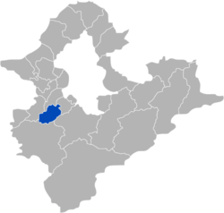
Tucheng District
Appearance
Tucheng
土城區 Dojō | |
|---|---|
| Tucheng District | |
 | |
 Location in New Taipei City | |
| Coordinates: 024°58′N 121°25′E / 24.967°N 121.417°E | |
| Country | Taiwan |
| Special municipality | New Taipei City |
| Area | |
• Total | 29.56 km2 (11.41 sq mi) |
| Population (February 2023) | |
• Total | 238,250 |
| Time zone | +8 |
| Website | www |
Tucheng District (Chinese: 土城區; pinyin: Tǔchéng Qū; Pe̍h-ōe-jī: Thô͘-siâⁿ-khu) is a district in the southwestern part of New Taipei City, Taiwan.

History
[edit]On 26 June 1993, Tucheng was upgraded from rural township to a county-administered city within Taipei County. On 25 December 2010, Taipei County was upgraded to New Taipei special municipality and Tucheng became a district.
Education
[edit]Tourist attractions
[edit]- Taiwan Nougat Creativity Museum[1]
- Tucheng Tung Blossom Park[2]
- Lin Family Garden
- FE21 Mall
- Cape No. 7 shooting scene
- Tianshang Mountain Recreation Area:[3] Tianshang Mountain raises to a height of 429.7 m. Originally named Neipo Mountain, this steep distinctive peak has been carved by the Xindian and Heng Rivers. Also known as 'Imperial' Mountain, it provides a scenic view.[4]
- Chengtian Chan Temple:[5] The Buddhist Chengtian Temple is located on Qingyuan Mountain east of Tucheng. It is a popular pilgrimage destination on weekends. A shady access path to the temple features an array of old stone tablets.
- Tucheng Riverside Park
- Paulownia Park
Transportation
[edit]
- National Highway No. 3
- Provincial Highway No. 3
- Taipei Metro: Bannan line (Blue) Line [Haishan, Tucheng, Yongning, and Dingpu stations]
- New Taipei Metro: Sanying line - Dingpu and Mazutian metro stations
See also
[edit]References
[edit]- ^ Taiwan Nougat Museum (in Chinese).
- ^ "新北市觀光旅遊網".
- ^ Hiking trail to Tianshang Shan 天上山步道 Archived 2008-11-21 at the Wayback Machine, Taiwanderful, January 29, 2007. Retrieved on November 29, 2008.
- ^ (from a pamphlet of the Teipei Metro, MRT)
- ^ Chengtian Chan Temple 承天禪寺 Archived 2009-05-05 at the Wayback Machine, Taiwanderful, January 29, 2007. Retrieved on November 29, 2008.
External links
[edit]Wikimedia Commons has media related to Tucheng District, New Taipei.
Wikivoyage has a travel guide for Tucheng.
- Official website
 (in Chinese)
 - Dingpu elementary school English website
