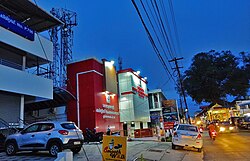
Koduvayur Gram Panchayat
Koduvayur | |
|---|---|
Town | |
 Koduvayur Main Road | |
 | |
| Country | |
| State | Kerala |
| District | Palakkad |
| Government | |
| • Type | Panchayati Raj |
| Area | |
• Total | 11.47 km2 (4.43 sq mi) |
| Population (2023)[1] | |
• Total | 28,500 |
| • Density | 2,500/km2 (6,400/sq mi) |
| Languages | |
| • Official | Malayalam, English[2] |
| Time zone | UTC+5:30 (IST) |
| PIN | 678501 |
| Vehicle registration | KL-09, KL-70 |
| Nearest city | Palakkad |
| Parliament constituency | Alathur |
| Assembly constituency | Nenmara |
Koduvayur is a town and a Panchayat in Palakkad district in the state of Kerala, India.[3] As of the 2011 Census of India, Koduvayur had a population of 20,703.[4] It is one of the major commercial centre in the district and is located about 11 km from Palakkad through State Highway 27
History
Along with the rest of the modern Palakkad district, Koduyavur lies in what was the Malabar District in British India. Koduvayur was one of the 18 asmams that comprised the Cheranad division of the colonial era Ernad Taluk, directly ruled by the Zamorin of Calicut. Its inclusion in this district was documented in William Logan's Malabar Manual published in 1887.[5]
Geography
Koduvayur is located roughly 10 km south of Palakkad along SH 27. It is bordered to the west and northwest by Thenkurissi, to the east by Puthunagaram, to the northeast by Peruvemba, and to the south by Pallassanna. The Malampuzha main canal flows southward through Koduvayur from the Malampuzha Dam.
Attractions


Koduvayur is home to a temple dedicated to the Hindu deity, Shiva. The temple is thought to have a 650-year-old history and played an important role in the initial settlement of Koduvaur. It is well-known for its Rathousalvam or chariot festival, attracting patrons from across Pallakad and the state Kerala. After 18 days of preparation for the festival, three idols or utsava moorthis, process around the temple and 9 times around a holy bunyan tree. The procession is accopmonied by celebrations, as well as fireworks as well as the Annadanam or sacred meal for devotees.[6]
Koduvayur grammam (agraharam) is a beautiful village with agraharam houses housed by Tamil Brahmins (Iyers) and has beautiful temples around it.
In the center of Koduvayur on Koduvayur Thrippalur Rd. is an outdoor market featuring produce and textiles.[7]
References
- ^ "Kerala (India): Districts, Cities and Towns - Population Statistics, Charts and Map".
- ^ "The Kerala Official Language (Legislation) Act, 1969" (PDF).
- ^ "Panchayaths | Palakkad | India". Retrieved 2 June 2021.
- ^ "Kerala (India): Districts, Cities and Towns - Population Statistics, Charts and Map". www.citypopulation.de. Retrieved 2 June 2021.
- ^ Logan, William (1951). Malabar. Reprinted by the Superintendent, Govt. Press. OCLC 576484196.
- ^ "KODUVAYUR RATHOLSAVAM KODUVAYUR TEMPLE" (PDF). Kerala Tourism.
- ^ Koduvayur Market, retrieved 2 June 2021
