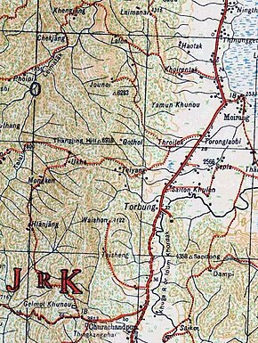
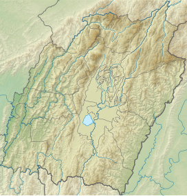
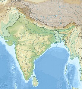
Thangjing Hill
| Thangjing Hill | |
|---|---|
| Highest point | |
| Elevation | 6,918 ft (2,109 m)[1] |
| Coordinates | 24°28′06″N 93°39′45″E / 24.4682°N 93.6624°E |
| Geography | |
| Location | Churachandpur district, Manipur |
| Country | India |
Thangjing Hill (also called Thangching Hill and Thangting Hill),[2] is a mountain peak in the Indian state of Manipur. It is in the Churachandpur district, to the west of Moirang.[3] The north-south-running mountain range on which it sits is also called Thangjing range or Thangjing Hills. The range forms part of the western border of the Imphal Valley.
The Thangjing Hill is believed by Manipuris to be the abode of Thangching, the ancestral deity of Moirang.[4][5] In the Meitei cosmology, the "body" of Manipur is represented with various natural features of the land, including the Thangjing hill as its right leg.[6]
The Meiteis of the Moirang region carry out an annual pilgrimage to the top of the hill.[3]
Geography
The Thangjing Hill is at an elevation of about 2,100 metres (6,900 ft) above the mean sea level. It is part of the western hill range that bounds the Imphal Valley.
Streams rising to the west of the hill flow into the Leimatak River, which flows north to join the Irang River. To the south rises the Tuila River, which joins the Tuivai River, a major river of the Churachandpur district. (Tuila was once considered the "Manipur source" of the Tuivai River, but now the main source is taken to lie in the Chin State of Myanmar, and Tuila considered its tributary.) To the east of the Thangjing Hill rise the Torbung and Kangvai streams, which water the villages named after them. To the southeast of the range rises the Lanva River, which flows south till Songpi, which is on an east-west ridge, and then turns east to drain into the Khuga River near Churachandpur.
Mythology
In Meitei mythology, the hill is mainly associated with the deity Eputhou Thangjing who is consideed the guardian of the mountain and the protector of the south of the Kanglei world.[7] The hill is also mentioned in the love story of Khamba Thoibi.[8]
History

The Thangjing Hill is much associated with Ancient Moirang people and its origin.[9] Thangjing Koirel Lai is the first king of Moirang and the name of the mountain Thangjing Hill is derived from his name.[10][11][12]In the 17th Century King Khagemba offered sacrifices in this sacred hill for the prosperity of his Kingdom.[13] The Kuki-Zo tribes also have historically lived around the Thangjing Hill. According the Moirang kings' chronicle Ningthourol Lampuba, the Koireng people, an "Old Kuki" tribe, used to be settled around the Thangjing Hill. The Moirangs under king Thingre Nachaoba raided them and defeated them. Historians believe that the Koirengs migrated away from the region due to the repeated incursions by the Moirang people. The Thangjing Hill was also deified by the Koireng people and the deity has since been adopted by the Moirangs, and eventually by the Meitei people in general.[14] The Chiru people, another Old Kuki tribe, have historical memory of having lived on the Thangjing Hill. The villagers later migrated to a new location in the present day Kangpokpi district for better availability of agricultural land and named the new village "Thangjing Chiru".[15]
After the Lushai Expedition of 1871–1872, Manipur received additional Kuki-Zo refugees from the Lushai Hills region, who were settled in the Thangjing Hills range and in the valley southwest of Moirang. Land and protection were provided by Raja Chandrakirti Singh, as well as food for subsistence till they could grow their own crops.[16] The Gazetteer of Manipur lists over 20 Kuki villages in the valley of the Tuila River, which flows south from the Thangjing Hills range.[17]
After the British took over Manipur as a princely state in 1891, they decided to administer the hill regions directly, outside the control of the Manipur State Darbar. Thangjing Hill came under the Southwest Subdivision, initially administered from Moirang.[18][19]
During the Kuki Rebellion of 1917–1919, the Thangjing Hills and the Ukha village played key roles.[20] In early 1917, the local chiefs met at Ukha and Henglep to discuss the emerging conflict with the British authorities.[21][22] After Mombi was burned by the British, an all-Kuki War Council was called by the chief of Chassad, and the chiefs received a signal to resist and fight. War preparations were begun in October after another gathering of chiefs.[23] The British attack came in December, led by the Political Agent J. C. Higgins. The Kukis staged an able defence, with sniper attacks and home-made leather cannons, causing several casualties on the British troops, but no Kuki was captured. Ukha was reportedly burnt down, and the Kukis escaped into the forests.[24][22] The failure of the operation and a similar one at Mombi stunned the British officers.[25] Another attack with a larger force was launched in February 1918, with similar results.[26] Eventually the rebellion was suppressed only by wholesale destruction of villages, including their livestock and foodgrains, driving the people into the woods to starve, along with women and children.[27]
After the Rebellion, the British reorganised their hill administration by establishing a new headquarters for the South-West Subdivision at Songpi (then called "Churachandpur"). The Churachandpur Subdivision eventually became the Churachandpur district in independent India in 1971.[28]
Post-independence history
An Indian Airlines Flight 257 on 16 August 1991 crashed into Thangjing Hills range, killing all 69 people on board.[29]
Occasional disputes have arisen over the Thangjing Hill, with the Kuki-Zos claiming to be the inhabitants of the region and the Meiteis claiming it to be their holy site. In 2010, a clash occurred between Meitei pilgrims on their annual pilgrimage and the local residents on the ground that the suspected group of 10 people wielding double barrel shot gun acted rowdily and misbehaved with the girl pilgrims and this sparked the tension , with two Kuki youth being killed and four injured.[30]
During 2014–2015, the Government of Manipur created a Thangting Subdivision in the Churachandpur district, using the Kuki spelling "Thangting" for the Thangjing Hill. The new subdivision was to include 66 villages, which were previously under the Churachandpur subdivision and the Henglep subdivision.[31] The move was seen by the Meiteis as an attempt to rename their sacred hill, and led to protests and shutdowns.[32][33] Eventually, the government renamed the subdivision as the Kangvai subdivision.[34]
In May 2022, Manipur forest officials led by the Principal Chief Conservator of Forests himself began a tree plantation drive in and around the Thangjing hill ranges to conserve from mass deforestation as a response to N. Biren Singh call for tree plantation drive and forest conservation which was supported by Meitei civil society organisations as well.[35] But, the Kuki Students Organisation (KSO) of the Henglep block raised the issue and barred the entry of meiteis which they claimed as "outsiders" into the hills without the permission of the village chief of the area.[36][37] KSO also claimed the village chief of the Ukha Loikhai village was mentioned as the "rightful owner" of the Thangjing Hill, whose permission was necessary for any such efforts.[38][39]
Notably Manipur Forest Department intensified mass tree plantation and encouraged public to participate in the tree plantation drive from June 5 2022 to August 31 2022.[40]
According to the state legislator (MLA) Paolienlal Haokip, gun-wielding members claiming to be members of Bharatiya Janata Yuva Morcha (BJYM) forced their way through the land-owning local people and attempted to forcibly afforest the Thangjing Hills.[41] The Kukis claimed that the Thangjing Hill came under the control of the Kuki chief of Ukha (now called Ukha Loikhai, 24°27′37″N 93°38′15″E / 24.4603°N 93.6374°E),[41][38][39][24] a village on the western slopes of the Thangjing Hill. The village is mentioned in the Gazetteer of Manipur as being at an elevation of 3,500 ft (1,100 m) above the sea-level, with a population of 150 people belonging to the "Changput subdivision of the Kongjai Kuki tribe".[42] Its current population per 2011 census is 418,[43] and the elevation on modern maps is 1,500 metres.
The Meitei community got organised under a Committee on Protection and Preservation of Historical Rights of Koubru and Thangjing Hill Range (CPPKT) and announced counter-restrictions on the hill people from entering the valley areas. A confrontation was averted by the involvement of the Director General of Police, P. Doungel, who arranged a negotiated settlement.[44] In October 2022, the Manipur cabinet proposed to include four hectares on the Thangjing Hill under Manipur Ancient and Historical Monuments Act in order to protect it from encroachments.[33]
Thangjing Hill came to be contested again during the 2023–2024 Manipur violence. Within a few weeks of the onset of violence in May, the Meiteis and Kukis were separated into their own areas. In September, the Kuki community installed a Christian cross on top of the Thangjing Hill, which the Meitei community regarded as desecration of their holy site.[45][2] It appears that the cross was later removed, presumably by Meitei activists. It was re-erected again in December, leading to loud protests from the Meitei community again. The Kukis have denied that the hill is exclusively a sacred site of the Meiteis.[46][33]
See also
Notes
References
- ^ Survey of India mapsheet 83-H, 1944.
- ^ a b Debanish Achom, Row Over Cross And Flag Atop Manipur's "Sacred" Hill, Police Case Filed, NDTV News, 6 October 2023.
- ^ a b Khelen Khokchom (19 April 2010). "Youths killed in clash over worship". The Telegraph (Kolkata).
- ^
Bhagat Oinam; Dhiren A. Sadokpam, eds. (2018), Northeast India: A Reader, Routledge India, p. 4, ISBN 978-0-429-95320-0, ISBN 978-0-429-48987-7 – via archive.org,
Along with the generation of 'origin myth', communities have also been engaged in 'sanctification' of these spatial demarcations and converting them as representations of revered deities. For instance, the Meiteis over the ages have attached cultural and religious significance to two mountain peaks: Koubru and Thangjing. In their cosmogony, the two peaks have been depicted as prime deities indicating control over marked territory.
- ^ Parratt, The Court Chronicle, Vol. 1 (2005), p. 184.
- ^ Ray, Sohini (2009). "Writing the Body: Cosmology, Orthography, and Fragments of Modernity in Northeastern India". Anthropological Quarterly. 82 (1): 129–154. ISSN 0003-5491.
The cosmology of the body as manifested in the land of Manipuris described as follows in oral accounts: Lake Khongampat is the heart; Kangla (the old royal fort) is the naval center. Lake Loktak is the reproductive organ; Nungthong in Sugnu is the anus and urethra. The three important rivers, Imphal, Iril, and Nambul form the veins and arteries. The Langol hill is the right hand, and the Thangjing hill the right leg. The Nongmaijing hill is the left hand. Wangbren hill is the left leg. Mountain Koubru, where we went for the pilgrimage is imagined to be the head of this body and also a center of many sacred myths in the Meitei faith.
- ^ Mangancha Thoudam Laiba, What Meiei myths and legends say of Lainingthou Thangching Koyelellai, the reigning deiy of the Thangjing ranges, Imphal Review of Arts and Politics, 6 February 2021.
- ^ Rojio, Usham (2022-06-07). "Performing the Landscape: Orature around Loktak Lake and the Love Story of Khamba Thoibi". Rupkatha Journal on Interdisciplinary Studies in Humanities. 14 (2). doi:10.21659/rupkatha.v14n2.ne38. ISSN 0975-2935.
- ^ Arambarn Parratt, Saroj Nalini (2009). The Court Chronicle of the Kings of Manipur. Foundation Books. ISBN 978-81-7596-638-3.
- ^ Session, North East India History Association (1988). Proceedings of North East India History Association. The Association. p. 45-46.
- ^ Singh, N. Tombi (1976). Khamba and Thoibi: The Unscaled Height of Love. Chitrebirentombichand Khorjeirup. p. 97.
- ^ Gosvāmī, Hareśvara (2019). History of the People of Manipur. YAOL. ISBN 978-1-9993057-0-3.
However, there are different opinions regarding the origin of Moirang. They are: (1) Moirang and Angom had a similar origin; (2) Moirang were descendants of god Thangjing....The hill where Thangjing Koirel Lai settled for some time came to be known as Thangjing Hill till today. From there they descended to the adjacent plains on the banks of the Loktak Lake, which was in occupation of none of the chiefs or kings for a long time. Thangjing Koirel Lai became king, and the history of Moirang began
- ^ Devi, Khwairakpam Renuka (2011). "Representation of the Pre-Vaishnavite Culture of the Meiteis: "Cheitharol Kumpapa" of Manipur". Proceedings of the Indian History Congress. 72: 501–508. ISSN 2249-1937.
During the reign of Meidingu Khagemba in the 17th century, all the Guardians of directions were worshipped by sacrificing hundreds of animals like buffaloes, goats, sheep, cows, ducks, cranes, pigeons, hens, pigs, and dogs. The ritual of worship also includes fruits and flowers of various kinds. These sacrifices were made for prosperous and long life of the peop
- ^ Somorjit, Wangam (2014), "Religious Milieu in Manipur", Mêyãmgi Kholão, 1 (4): 77–151, ISSN 2320-4583
- ^ Village Survey Monograph, 21-Thangjing Chiru, Part VI, Vol-XXII, Manipur - Census 1961, Office of the Registrar General & Census Commissioner of India, 1966, pp. 1–2
- ^ Brown, Statistical Account of Manipur (1874), p. 56.
- ^ Dun, Gazetteer of Manipur (1886): Some of the villages listed are Chanjang (p. 77), Lamjang (p. 141), Mangne (p. 159) etc.
- ^ Lal Dena, Lal Robul Pudaite, Colonial Divide In Manipur: Tracing The Journey Of State Between 1835 And 1947, Outlook, 4 September 2023.
- ^
Singh, Karam Manimohan (1991), History of Christian Missions in Manipur, Mittal PUblications, p. 270 – via archive.org,
The Governor placed on record the boundaries of the Churachandpur Sub-Division. The area was bounded on the west and the south by the State border: the eastern boundary was the well defined natural line of the Manipur River: but the northern boundary was not capable of such accurate definition which was to approximate the Manipur bridle path [Cachar Road].
- ^ Haokip, These Crafty Jungle Fighters (2019), p. 123: "In the Southwestern hills, Pakang (Henglep), Semchung (Ukha), Haoneh (Nabil) and Paosum (Songphu) led the war.".
- ^ Guite, Fighting the White Men till the Last Bullet (2019), pp. 38–39: "Aishan’s announcement was followed by a series of meetings held in different parts of Kuki hills – Chassad, Jampi, Taloulong, Mombi, Ukha, Henglep, etc.".
- ^ a b Kuki Inpi Manipur, Anglo-Kuki War (1917-1919), Imphal Free Press, 29 September 2019. ProQuest 2298810123
- ^ Guite, Fighting the White Men till the Last Bullet (2019), p. 42.
- ^ a b Guite, Fighting the White Men till the Last Bullet (2019), p. 47.
- ^ Guite, Fighting the White Men till the Last Bullet (2019), pp. 47–48.
- ^ Haokip, These Crafty Jungle Fighters (2019), p. 125.
- ^ Haokip, Breaking the Sprit of the Kukis (2019), p. 100.
- ^ Manipur Administrative Atlas (PDF), Census of India, Government of India, 2005, pp. 16–17
- ^ Ranter, Harro. "ASN Aircraft accident Boeing 737-2A8 Advanced VT-EFL Imphal Municipal Airport (IMF)". aviation-safety.net. Retrieved 2020-12-23.
- ^ [1]
- ^ Cabinet approves five more sub-divisions in hills, Imphal Free Press, 8 August 2014. ProQuest 1551745396
- ^ Bandh cripples Bishnupur district, Imphal Free Press, 8 January 2016. ProQuest 1754357860
- ^ a b c Ratnadip Choudhury, Cross Installed Atop Manipur's "Sacred" Hill Threatens Fragile Peace, NDTV News, 3 February 2024.
- ^ Cabinet decision to rename 'Thangting sub-division' incurs stiff opposition, Imphal Free Press, 15 February 2016. ProQuest 1765070770
- ^ [2]
- ^ KSO bans tree plantation at Thangjing Hill by CSOs, Imphal Times, 6 May 2022.
- ^ Jimmy Leivon, Amid tensions between groups, Manipuri activist arrested, The Indian Express, 22 May 2022.
- ^ a b Loikhai village chief is owner of Thangjing Hill; Student body KSO Henglep Block stakes more claims, The Sangai Express, via e-pao.net, 17 May 2022.
- ^ a b Chief clarifies, The Sangai Express, 10 May 2022.
- ^ [3]
- ^ a b BJP MLA Paolienlal Haokip Slams BJYM’s Attempt To Plant Trees On Thangjing Hill, The Frontier Manipur, 17 May 2022.
- ^ Dun, Gazetteer of Manipur (1886), p. 223.
- ^ Churachandpur District Census Handbook (2011), p. 134.
- ^ DGP averts Thangjing crisis; feuding CSOs agree to retract statements, Imphal Free Press, 23 May 2022. ProQuest 2668098877
- ^ Cross and flag of ZRA found erected on Mt Thangjing Meitei's sacred site desecrated, The Sangai Express, 23 September 2023.
- ^ Re-installation of Cross atop Mt Thangjing CPPKT decries, demands legal action, The Sangai Express, 2 December 2023.
Bibliography
- Churachandpur District Census Handbook (PDF), Directorate of Census Operations, Manipur, 2011
- Brown, R. (1874), Statistical Account of the Native State of Manipur and the Hill Territory under Its Rule, Calcutta: Office of the Superintendent of Government Printing
- Dun, E. W. (1992) [1886], Gazetteer of Manipur, Manas Publications – via archive.org
- Jangkhomang Guite; Thongkholal Haokip, eds. (2019), The Anglo-Kuki War, 1917–1919: A Frontier Uprising against Imperialism during World War I, Routledge, ISBN 978-1-138-50704-3
- Guite, Jangkhomang (2019), "'Fighting the White Men till the Last Bullet': The general course of the Anglo-Kuki War", Ibid, pp. 37–
- Haokip, D. Letkhojam (2019), "'These Crafty Jungle Fighters': Tactics, technology and symbols of Kuki war", Ibid, pp. 118–
- Haokip, Thongkholal (2019), "Breaking the Spirit of the Kukis: Launching the 'largest series of military operations' in the northeastern frontier of India", Ibid, pp. 93–
- Parratt, Saroj Nalini Arambam (2005). The Court Chronicle of the Kings of Manipur: The Cheitharon Kumpapa, Volume 1. London: Routledge. ISBN 9780415344302.
- Parratt, Saroj Nalini Arambam (2009). The Court Chronicle of the Kings of Manipur: The Cheitharon Kumpapa, Volume 2. Foundation Books / Cambridge University Press India. ISBN 978-81-7596-854-7.
- Pau, Pum Khan (2019), Indo-Burma Frontier and the Making of the Chin Hills: Empire and Resistance, Taylor & Francis, ISBN 9781000507454
External links
- Leimatak River, OpenStreetMap, retrieved 13 February 2024.
- Tuila River, OpenStreetMap, retrieved 13 February 2024.
- Lanva River, OpenStreetMap, retrieved 13 February 2024.
- Ukha Road (between Henglep and Torbung), OpenStreetMap, retrieved 13 February 2024.


