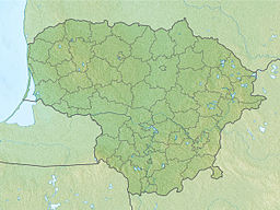
Tauragnas
Appearance
| Lake Tauragnas | |
|---|---|
 Tauragnas lake near Tauragnai | |
| Coordinates | 55°26′17″N 25°52′47″E / 55.43806°N 25.87972°E |
| Basin countries | Lithuania |
| Max. length | 9 km (5.6 mi) |
| Max. width | 1 km (0.62 mi) |
| Surface area | 5.13 km2 (1.98 sq mi) |
| Average depth | 18.7 m (61 ft) |
| Max. depth | 62.1 m (204 ft) |
| Settlements | Tauragnai |
Tauragnas is the deepest lake in Lithuania reaching 62.5 metres of depth. The surface area is 5.13 km2 and average depth 18.7 m. It is situated in Aukštaitija National Park near Tauragnai in Utena County. This is also a lake with the highest altitude (above sea level) in Lithuania.[1][2] [3]
See also
[edit]References
[edit]- ^ "Ežerai". In: Enciklopedija „Lietuva“, vol. I. Vilnius: Mokslo ir enciklopedijų leidybos institutas, 2008
- ^ "Tauragnas". In: Tarybų Lietuvos enciklopedija, vol. 4 (Simno-Žvorūnė). Vilnius: Vyriausioji enciklopedijų redakcija, 1988.
- ^ Aleksandras Vanagas, 1981: Lietuvių hidronimų etimologinis žodynas. Vilnius: Mokslas, 1981, p. 342
Wikimedia Commons has media related to Tauragnas.

