Bashagard County
Bashagard County
| |
|---|---|
County | |
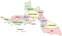
 Location of Bashagard County in Hormozgan province (right, yellow) | |
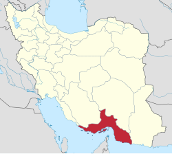
 Location of Hormozgan province in Iran | |
| Coordinates: 26°30′00″N 58°13′30″E / 26.50000°N 58.22500°E[1] | |
| Country | |
| Province | Hormozgan |
| Capital | Sardasht |
| Districts | Central, Gafr and Parmon, Gowharan |
| Population (2016)[2] | |
• Total | 35,085 |
| Time zone | UTC+3:30 (IRST) |
Bashagard County (Template:Lang-fa) is in Hormozgan province, in southern Iran. Its capital is the city of Sardasht.[3]
After the National Census of 2006, Bashagard District was separated from Jask County in the establishment of Bashagard County, which was divided into three districts of two rural districts each, with the city of Sardasht as its capital.[3]
The census in 2011 counted 40,007 people in 9,571 households.[4] At the 2016 census, the county's population was 35,085 in 9,359 households.[2]
Administrative divisions
The population history and structural changes of Bashagard County's administrative divisions over two consecutive censuses are shown in the following table. The latest census shows three districts, six rural districts, and two cities.[2]
| Administrative Divisions | 2011[4] | 2016[2] | |
|---|---|---|---|
| Central District | 15,041 | 13,676 | |
| Jakdan RD | 11,700 | 10,053 | |
| Sardasht RD | 1,805 | 1,898 | |
| Sardasht (city) | 1,536 | 1,725 | |
| Gafr and Parmon District | 8,478 | 7,260 | |
| Gafr RD | 3,220 | 2,808 | |
| Parmon RD1 | 5,258 | 4,452 | |
| Gowharan District | 16,488 | 14,149 | |
| Dar Absar RD | 5,746 | 5,011 | |
| Gowharan RD | 9,426 | 7,968 | |
| Gowharan (city) | 1,316 | 1,170 | |
| Total | 40,007 | 35,085 | |
| RD: Rural District 1Formerly Gafr and Parmon Rural District[3] | |||
Agriculture and climate
This section needs additional citations for verification. (September 2023) |
Bashagard experiences cold winters and hot, dry summers, but the climate is more tolerable in areas that are nearer to the mountains. Garlic from the county is of extremely high quality because it is aromatic, sharp, and pungent. Dates are one of the county's most significant agricultural products. Pomegranates and figs are among the available seasonal fruits.
Wild cherry (also known as bestel, which is especially crucial for treating anemia in medicine), bitter almonds, wild pistachios, and cumin are some of the other goods produced in the highlands throughout the various seasons. Wild edible mushrooms, also referred to as "Akhur" locally, are a highly favored and nutrient-dense food that flourishes in the highlands during the winter.
Bashagard honey is of the highest quality and is exported to nations along the Persian Gulf as well as further abroad.
References
- ^ OpenStreetMap contributors (6 September 2023). "Bashagard County" (Map). OpenStreetMap. Retrieved 6 September 2023.
- ^ a b c d "Census of the Islamic Republic of Iran, 1395 (2016)". AMAR (in Persian). The Statistical Center of Iran. p. 22. Archived from the original (Excel) on 5 May 2022. Retrieved 19 December 2022.
- ^ a b c Davoodi, Parviz (28 July 1387). "Divisional changes and reforms in Hormozgan province". Laws and Regulations Portal of the Islamic Republic of Iran (in Persian). Ministry of Interior, Board of Ministers. Archived from the original on 6 September 2023. Retrieved 6 September 2023.
- ^ a b "Census of the Islamic Republic of Iran, 1390 (2011)". Syracuse University (in Persian). The Statistical Center of Iran. p. 22. Archived from the original (Excel) on 17 January 2023. Retrieved 19 December 2022.

