Minna
This article includes a list of general references, but it lacks sufficient corresponding inline citations. (November 2022) |
Minna, Niger state | |
|---|---|
State Capital and city | |
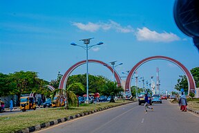
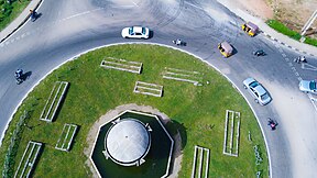
From top, left to right: Minna City gate (entrance); Welcome to Minna; Bahago roundabout; Minna central mosque; St. Michael's Cathedral; Tunga roundabout; | |
 | |
| Country | |
| State | Niger State |
| Government | |
| Population (2007) | |
• Total | 304,113 |
| Time zone | UTC+1 (WAT) |
| Climate | Aw |
 | |
Minna is a city in Middle Belt Nigeria. It is the capital city of Niger State, one of Nigeria's 36 federal states. It consists of two major ethnic groups: the Gbagyi and the Nupe.

History
Archaeological evidence suggests settlement in the area dates back to about 47,000–37,000 years ago. Muslim culture filtered into Minna by way of the ancient Saharan trade routes much later, and the city contains many mosques including Minna Central Mosque and Muslim organizations like the Islamic Education Trust, Minna, Muslim Students' Society of Nigeria - Minna Area Council (MSSN-MNAC), Da'watu-Ilallahi-Wa-Rasulihi Association (DAWRA), etc. Sharia law is practiced. Christianity is the second major population in Niger State, and institutions include a Faith Church, a Grace Baptist Church, Nupe Kalvari Churches, Anglican Churches, ECWA Churches, Baptist Churches, Victory Christian Church, the Apostolic Church and many others.
Minna is the home state of Nigeria's former military President Gen. Ibrahim B. Babangida, and of former Head of State Gen. Abdulsalami Abubakar. Dr. Mu'azu Babangida Aliyu was the former governor of Niger State, serving the maximum term of eight years (2007–2015). Abubakar Sani Bello is also former governor of Niger state served from 2015 - 2023, the present governor of Niger state who took over from the opposition party ruling candidate of the Peoples Democratic Party candidate Mu'azu Babangida Aliyu, serving his second term in office.
Pollution
Based on research carried out, it was reported that minna is being affected by land pollution caused by non-proper disposal of solid waste products. This has cause several disease such as Malaria fever, Yellow fever, Lassa fever, etc.[1]
Climate
Minna has a typical Middle Belt tropical savanna climate (Köppen Aw) with two seasons: an arid, dusty, harmattan-dominate dry season from November to April and a humid, oppressive wet season dominated by monsoonal air masses from May to October. Temperatures are hot to sweltering year round, except at the height of the wet season when air temperatures are merely very warm but the high humidity makes it equally or more uncomfortable than the hotter dry season. Due to the monsoon, summer (June, July, August) is cooler than spring, fall and winter.
| Climate data for Minna (1961–1990) | |||||||||||||
|---|---|---|---|---|---|---|---|---|---|---|---|---|---|
| Month | Jan | Feb | Mar | Apr | May | Jun | Jul | Aug | Sep | Oct | Nov | Dec | Year |
| Mean daily maximum °C (°F) | 34.7 (94.5) |
36.8 (98.2) |
37.1 (98.8) |
35.7 (96.3) |
32.8 (91.0) |
30.7 (87.3) |
29.5 (85.1) |
28.8 (83.8) |
30.0 (86.0) |
32.0 (89.6) |
34.4 (93.9) |
34.7 (94.5) |
33.1 (91.6) |
| Daily mean °C (°F) | 27.6 (81.7) |
29.3 (84.7) |
30.2 (86.4) |
28.9 (84.0) |
27.3 (81.1) |
26.0 (78.8) |
25.1 (77.2) |
25.2 (77.4) |
24.9 (76.8) |
26.3 (79.3) |
26.9 (80.4) |
26.7 (80.1) |
27.0 (80.6) |
| Mean daily minimum °C (°F) | 20.4 (68.7) |
22.8 (73.0) |
24.5 (76.1) |
24.8 (76.6) |
23.7 (74.7) |
22.3 (72.1) |
22.1 (71.8) |
21.8 (71.2) |
21.6 (70.9) |
21.5 (70.7) |
19.4 (66.9) |
19.3 (66.7) |
22.0 (71.6) |
| Average rainfall mm (inches) | 1.4 (0.06) |
5.4 (0.21) |
11.9 (0.47) |
60.9 (2.40) |
135.9 (5.35) |
174.5 (6.87) |
206.6 (8.13) |
271.9 (10.70) |
239.9 (9.44) |
100.0 (3.94) |
1.2 (0.05) |
0.1 (0.00) |
1,209.7 (47.63) |
| Average rainy days (≥ 1.0 mm) | 0.1 | 0.2 | 1.3 | 4.2 | 9.4 | 12.3 | 14.0 | 16.2 | 16.9 | 8.6 | 0.3 | 0.1 | 83.6 |
| Average relative humidity (%) (at 15:00 LST) | 21.2 | 20.6 | 28.3 | 42.0 | 57.5 | 65.4 | 71.4 | 74.0 | 69.9 | 60.3 | 34.2 | 25.2 | 47.5 |
| Mean monthly sunshine hours | 226.3 | 215.6 | 220.1 | 210.0 | 226.3 | 189.0 | 155.0 | 148.8 | 180.0 | 248.0 | 267.0 | 269.7 | 2,555.8 |
| Mean daily sunshine hours | 7.3 | 7.7 | 7.1 | 7.0 | 7.3 | 6.3 | 5.0 | 4.8 | 6.0 | 8.0 | 8.9 | 8.7 | 7.0 |
| Source: NOAA[2] | |||||||||||||
Economy

Cotton, guinea corn (sorghum), Maize and ginger are the main agricultural products of the city. Yam is also extensively cultivated throughout the city. The economy also supports cattle trading, brewing, shea nut processing and gold mining. There are also FMCGs such as PZ Cussons that deal in toilet soaps, baby products, medicaments and so on. [3] Traditional industries and crafts in Minna include leather work and metalworking.
Transport

Minna is connected to neighbouring cities by road. Abuja, the capital of the country, is only 150 km away. Minna is also connected by railroad to both Kano in the north and Ibadan and Lagos in the south. The city is served by Minna Airport.
Education and Health
Minna has many educational institutions, including:Fati Lami Abubakar Institute for Legal and Administrative Studies, The Federal University of Technology Minna, Niger state school of health, Niger state school of nursing and Midwifery, Niger state university of Education among others. With many high schools as Father O'Connell Science College, Minna, Waziri Primary School, Chiroma Primary School, D.S.S Limawa, Kowa Schools, El-Bethel Academy, Jocis Schools, Hilltop Model School, Mypa schools, Himma international school, Police secondary school, El-Amin International School, FOMWAN Schools, New Horizon College, Divine Excellence International Schools and Brighter International Schools, among many others. The above-mentioned schools are the pioneering high schools in Minna. Minna has many primary health clinics with the General Hospital, Minna serving as the general health care.[4][5]
Universities
- Federal University of Technology Minna
- Niger State College of Education
- School of Nursing and Midwifery
- New Gate Science and Technology
- Niger State Polytechnic
- The Federal Polytechnic Bida
Gallery
-
Niger state Secretariat
See also
References
- ^ Christopher Ileanwa, Abdul; Macaulay Atahchegbe, Egwuma; Andrew Ekule, Adejoh (1 June 2020). "Impact of land pollution on the wellbeing of neighborhoods in Minna Metropolis of Nigeria". Central Asian Journal of Environmental Science and Technology Innovation. 1 (3): 143–149. doi:10.22034/CAJESTI.2020.03.03. ISSN 2717-4034.
- ^ "Minna Climate Normals 1961–1990". National Oceanic and Atmospheric Administration. Retrieved 22 July 2016.
- ^ "The Concice Britannica Encyclopaedia". Retrieved 20 February 2007.
- ^ ALFA, M T (2019). "Perceived Indoor Environmental Quality of Hospital Wards and Patients' Outcomes: A Study of a General Hospital, Minna, Nigeria". Applied Ecology and Environmental Research. 17 (4). doi:10.15666/aeer/1704_82358259. ISSN 1589-1623.
- ^ Annual Engineering Conference of the School of Engineering and Engineering Technology (6th : 2005 : Federal University of Technology, Minna, Nigeria) (2005). Book of proceediings : theme: engineering and technology for wealth creation in the spirit of needs, date: 15th - 17th June, 2005 : 6th Annual Engineering Conference, School of Engineering and Engineering Technology, Federal University of Technology, Minna. [The University]. ISBN 978-36536-2-8. OCLC 154725099.
{{cite book}}: CS1 maint: multiple names: authors list (link) CS1 maint: numeric names: authors list (link)


