Satkhira
Appearance
Satkhira
সাতক্ষীরা satghoria (old name) | |
|---|---|
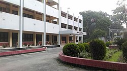
 Circuit House, Satkhira | |
| Coordinates: 22°43′08″N 89°04′17″E / 22.718802°N 89.071277°E | |
| Country | |
| Division | Khulna |
| District | Satkhira |
| Upazila | Satkhira Sadar |
| Government | |
| • Type | Mayor–Council |
| • Body | Paurashava (Municipal Corporation) |
| • Mayor | Tazkin Ahmed Chishti |
| Area | |
• Total | 32.39 km2 (12.51 sq mi) |
| • Rank | 39th |
| Population (2011) | |
• Total | 113,322 |
| • Density | 3,500/km2 (9,100/sq mi) |
| Time zone | UTC+6 (Bangladesh Time) |
| National Dialing Code | +880 |
Satkhira(Template:Lang-bn) is a city and district headquarter of Satkhira District in Khulna Division, southwestern Bangladesh. The city has a population of about 113,000, making it the 20th largest city in Bangladesh. Satkhira also has a large proportion of the Sundarbans rainforest of Bangladesh.
Demographics
At the time of the 2011 census, Satkhira had 26,896 households and a population of 113,322. 20,102 (17.74%) were under 10 years of age. Satkhira has a sex ratio of 967 females per 1000 males and a literacy rate of 69.3%.[1][2]
References
- ^ a b "Bangladesh Population and Housing Census 2011 Zila Report – Satkhira" (PDF). bbs.gov.bd. Bangladesh Bureau of Statistics.
- ^ "Community Tables: Satkhira district" (PDF). bbs.gov.bd. Bangladesh Bureau of Statistics. 2011.


